An Overlooked Summit in the Oxford Hills
Mount Tire’m rises to 1,060 feet in the town of Waterford, deep in the western Maine lake country between Kezar Lake and Norway. The name is old and unusual, and no one is quite sure of its origin, though it has appeared on maps for well over a century. The hike is short, roughly 0.7 miles to the summit, with about 577 feet of elevation gain, and it delivers a surprisingly rewarding set of views for such a small mountain.
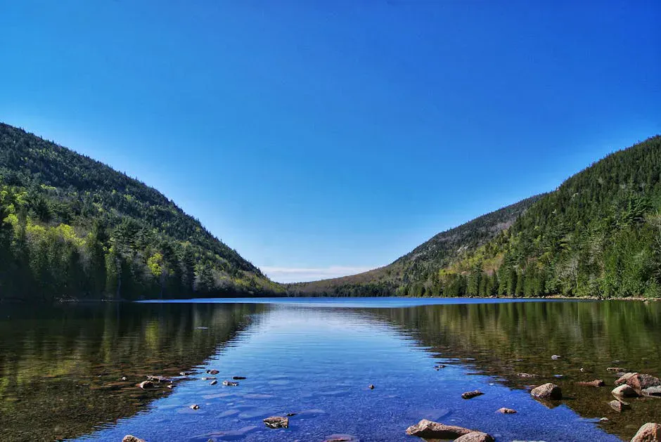
From the open ledges near the top, you look southeast over Keoka Lake, Bear Pond, and Long Lake, with Pleasant Mountain and the Shawnee Peak ski area visible on the horizon. The White Mountains in New Hampshire fill the western skyline on clear days. The summit area has blueberry bushes, interesting rock formations, and a glacial erratic that forms a small cave popular with kids. It is one of those hikes that locals love and tourists rarely find.
The Trail
The Daniel Brown Trail is the standard route up Mount Tire’m. The trailhead is on Plummer Hill Road in Waterford, just northwest of the village center and a short distance past the Congregational Church. There is no formal parking lot, just a roadside pulloff that fits a handful of cars. The trailhead is unmarked but well-worn and easy to spot once you know where to look.
The trail climbs steadily through mixed hardwood and softwood forest. The lower section is well-shaded and moderate in grade. As you gain elevation, the forest thins and the trail becomes steeper, with a few sections of exposed ledge and rock scrambling. None of it requires hands, but sturdy footwear helps.
Near the summit, the trail opens onto broad granite ledges with views to the south and east. The true summit is a short walk farther along the ridge, where additional views open up to the west toward the White Mountains.
The glacial erratic near the summit forms a small cave or shelter in the rock that children love to explore. It is a fun highlight for families and makes a natural rest stop before the final push to the top.
The Views
The southeast-facing ledges are the main attraction. Keoka Lake sits directly below, long and narrow, with cottages and camps lining its shores. Bear Pond and Long Lake are visible beyond, and Pleasant Mountain’s ski trails are obvious on the horizon. In fall, the entire landscape is a quilt of red, orange, and gold.
To the west, the ridgeline of the White Mountains stretches across the horizon. On the clearest days, the major peaks of the Presidential Range are identifiable. The views are not as sweeping as what you get from bigger mountains, but the intimacy of the scene, lakes set in rolling hills, is the charm.
When to Go
Spring
Muddy in the lower forest. The ledges dry quickly. Wildflowers in the woods in May.
Summer
Blueberries ripen in late July. Shaded lower trail is pleasant on hot days. Bring bug spray.
Fall
Foliage views over the lake country are outstanding. Cool, dry air and clear skies.
Winter
Short enough for a winter outing. Exposed ledges can be icy. Microspikes recommended.
Late September through early October is the ideal window. The foliage in the Oxford Hills is some of the best in the state, and from the summit ledges you see it reflected in the lakes below.
Practical Notes
The mountain is spelled “Mount Tire’m” on official maps, with the apostrophe. Locals just say “Mount Tirem” or sometimes “Tire Mountain.” If you are asking for directions in Waterford, any of these will get you pointed the right way.
Waterford is a small, quiet village with no gas station or general store. The nearest services are in Norway or South Paris, about 15 to 20 minutes away. There are no bathrooms at the trailhead.
Dogs are welcome and the trail is manageable for most dogs. The rocky ledges near the top may challenge very small or elderly dogs.
Mount Tire'm Day Hike
- Water bottle
- Sturdy shoes with good grip for ledges
- Bug spray in summer
- Container for blueberries (late July-August)
- Camera
- Light layer for the summit breeze
Getting There
From the junction of Route 35 and Route 37 in Waterford, head south on Route 35/37 about 500 feet and turn right onto Plummer Hill Road. The trailhead is a short distance past the Congregational Church on the left, marked by a worn path entering the woods. From Portland, the drive takes about an hour and 20 minutes via Route 302 and Route 35. From Norway, it is about 15 minutes north on Route 118.
FAQ
How long does the Mount Tire'm hike take?
About 1 to 1.5 hours round trip. The trail is roughly 0.7 miles to the summit with moderate steepness. Most of the time is spent enjoying the views and exploring the summit rocks.
Is Mount Tire'm good for kids?
Yes. The hike is short enough for children ages 5 and up, and the summit cave and blueberries make it engaging for kids. The steep ledge sections near the top require some attention with younger children.
Where is the trailhead?
On Plummer Hill Road in Waterford, just past the Congregational Church. There is no sign, but the worn path into the woods is visible from the road. Park along the shoulder.
Can I see Kezar Lake from the summit?
Kezar Lake is not directly visible from the main summit ledges, which face southeast toward Keoka Lake and Bear Pond. However, views to the west include the broader lake region and the White Mountains beyond.
Are there blueberries?
Yes. Wild blueberry bushes grow on the summit ledges and produce well in late July and August. Bring a container if you visit during berry season.
For more hiking in the area, see our guides to Kezar Lake and the Pleasant Mountain Ledges Trail.