The Quieter Side of the Tumbledown Range
Tumbledown Dick sits on the eastern end of the Tumbledown range in the 10,000-acre Tumbledown Public Reserved Land, just north of Weld in Franklin County. While hikers crowd the trails up nearby Tumbledown Mountain for its famous alpine pond, Tumbledown Dick draws a fraction of the foot traffic. The reward is open ridge walking, broad views across the western mountains, and the kind of solitude that Tumbledown Mountain used to offer before it became one of the most popular hikes in the state.
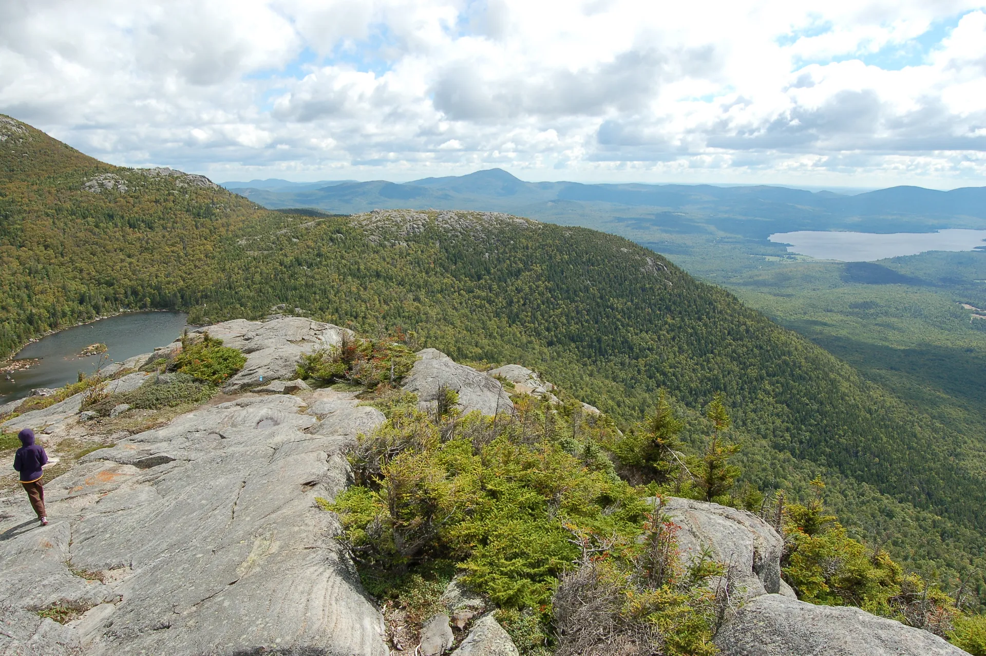
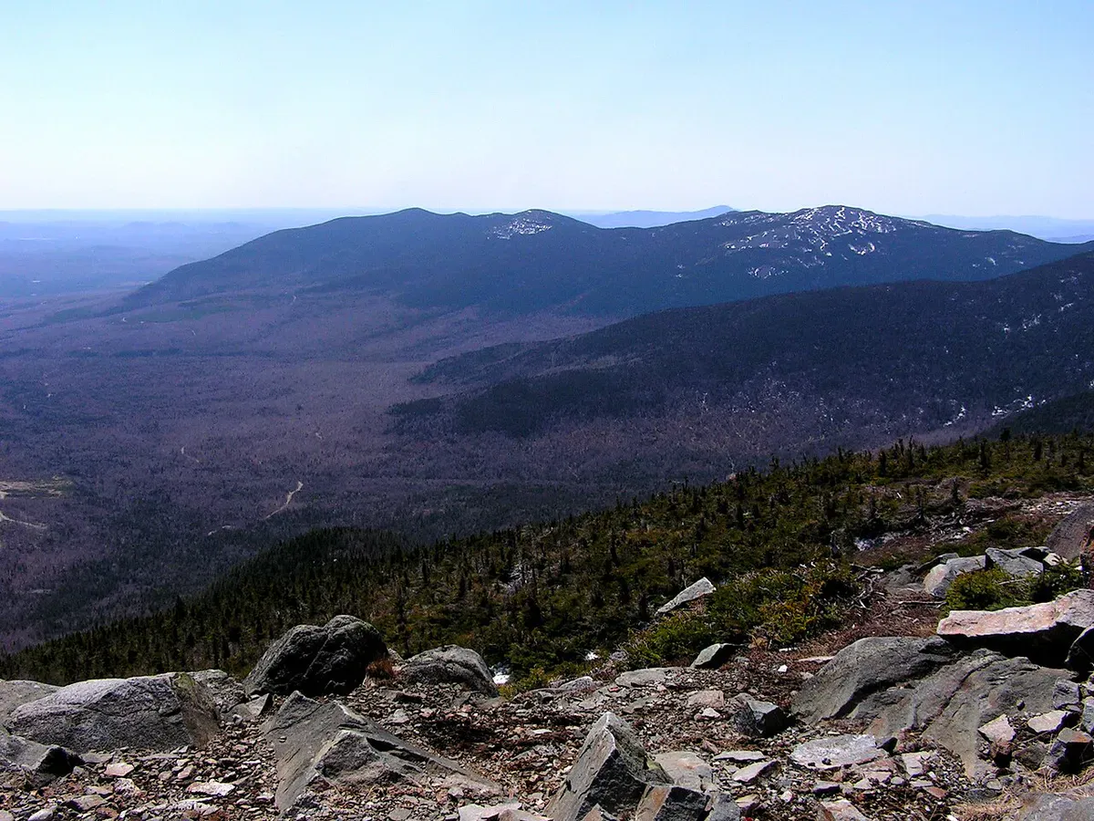
The mountain is part of a connected ridgeline that includes Tumbledown, Little Jackson Mountain, and Big Jackson. On a clear day from the ridge you can see across Webb Lake below to Mount Abraham and the Crocker range, with the Rangeley Lakes region stretching out to the northwest. The terrain is typical of Maine’s western mountains: spruce and fir forests at elevation, mixed hardwoods lower down, and open ledge along the ridgeline where the views open up.
The Trail
The hike to Tumbledown Dick follows trails within the Tumbledown Public Reserved Land, starting from the Byron Road trailheads north of Weld. The route climbs through mixed forest before gaining the ridge that connects the peaks in the Tumbledown range. The total round trip is about 5.5 miles with roughly 1,600 feet of elevation gain.
The lower sections are well-graded through birch and beech forest. As you climb, the trail transitions to spruce and fir, with rocky footing that requires attention. The final push to the ridge involves some moderate scrambling over ledge, but nothing requiring hands-and-knees work. Once on the ridge, the walking opens up with exposed rock and low scrub, giving you views in nearly every direction.
The ridge section is the highlight. You can see the cliffs of Tumbledown Mountain to the west, Webb Lake directly below to the south, and the long line of peaks running northeast toward Saddleback and Sugarloaf. On autumn days with good visibility, the foliage in the valleys below the ridge is exceptional.
If you want to extend the hike, you can traverse the ridge to connect with trails on Tumbledown Mountain or Little Jackson Mountain. A car shuttle or an out-and-back from the ridge junction makes a full day of it.
When to Go
Spring
Trails are muddy through May. Snowpack lingers on the ridge into early May. Black flies arrive in late May and stick around through June.
Summer
Dry trail conditions and long days for ridge walking. Bring bug spray through July. Start early to avoid afternoon thunderstorms.
Fall
Peak foliage in late September through early October. Cool air, clear views, and no bugs. The hardwood valleys below the ridge are spectacular.
Winter
Byron Road is not plowed to the trailhead, adding significant distance. Snowshoes or skis required. The ridge is exposed to wind.
The first two weeks of October are the prime window. The hardwood forests below the ridgeline turn gold and orange while the spruce stays dark green, and the contrast from the summit ridge is one of the best fall views in Franklin County.
Practical Notes
The Byron Road trailheads serve multiple trails in the Tumbledown range. On busy fall weekends, the parking areas for Tumbledown Mountain fill up early. Tumbledown Dick shares some of the same access, so arrive by 8am during peak foliage if you want a spot. Weekdays are far quieter.
The access road is gravel and well-maintained in summer but can be rough in spring. Most passenger vehicles can make it to the trailhead without trouble from June through October. There are no facilities at the trailhead beyond a small parking area.
Cell service is nonexistent in this area. Download your maps and let someone know your plans before you drive in.
Packing List
Tumbledown Dick Day Hike
- 2 liters of water per person
- Trail snacks and lunch for the ridge
- Bug spray May through July
- Wind layer for the exposed ridge
- Sturdy hiking boots with ankle support
- Map of the Tumbledown range (no cell service)
- Sun protection for the open ridge
- Camera
Getting There
From Weld, take Byron Road north. The road is paved out of town and transitions to gravel as it enters the Tumbledown Public Reserved Land. The trailheads are well-signed along Byron Road, roughly 6 miles from the center of Weld. From Portland, the drive takes about 2.5 hours via Route 4 through Farmington and then Route 156 to Weld. From Bangor, take Route 2 west to Farmington, then north to Weld, also about 2.5 hours.
Gas up in Farmington or Weld before heading in. There are no services on Byron Road.
FAQ
How long does the Tumbledown Dick hike take?
Most hikers complete the 5.5-mile round trip in 3.5 to 5 hours, depending on how much time they spend on the ridge. The ridge walking is the highlight and worth lingering over.
Is Tumbledown Dick less crowded than Tumbledown Mountain?
Significantly. Tumbledown Mountain is one of the most popular hikes in western Maine, drawing large crowds on weekends. Tumbledown Dick sees a fraction of that traffic and offers comparable views from the ridge.
Can I combine Tumbledown Dick with Tumbledown Mountain?
Yes. The ridge trail connects the two peaks, and experienced hikers can traverse the full ridgeline in a long day. A car shuttle between trailheads makes the logistics easier.
Are dogs allowed?
Yes. The Tumbledown Public Reserved Land allows dogs. Keep them under control on the exposed ridge sections and bring extra water for them.
Is the road to the trailhead passable?
Byron Road is gravel but well-maintained from late spring through fall. Most vehicles can handle it. In early spring or after heavy rain, drive cautiously. The road is not plowed in winter.
For more hikes in the area, see our guides to Tumbledown Mountain, Little Jackson Mountain, and Mount Abraham.