The Trail Acadia Doesn’t Advertise
Acadia National Park has over 150 miles of maintained trails, and most of them are well-marked, well-documented, and well-traveled. Owl Head is none of those things. This short but punishing scramble up the western side of the quiet end of Mount Desert Island leads to a granite cliff with a view that rivals anything on Cadillac Mountain, and on most days you will have it entirely to yourself.
The trail does not appear on official park maps. There are no blazes, no signs, and no maintained tread. What exists is a social path beaten into the forest floor by hikers who heard about it from other hikers who heard about it from locals who have been climbing up here for decades. The route is only about 0.4 miles one way, but it gains roughly 160 feet of elevation through root-choked forest and ends with a hands-and-feet rock scramble up exposed granite slabs.
At the top, the reward is immediate. You stand on a broad granite ledge with the Atlantic spread out below, Ship Harbor to the east, Bass Harbor Head Lighthouse visible across the water, and the open ocean stretching south to nothing. On a clear day, the views extend to the Cranberry Isles and beyond.
Finding the Trailhead
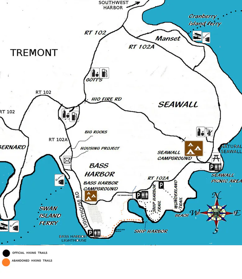
This is where most people get lost. The unofficial trailhead sits along the Ship Harbor Trail parking area on Route 102A, on the western side of the island. The social path begins near the eastern end of the parking lot, entering the woods on the north side of the road. Look for a narrow gap in the trees and possibly a few cairns or beaten-down brush marking the entry point.
This is not a maintained trail. There are no blazes, no signs, and no improved tread. The route involves steep scrambling over loose rock and exposed roots with significant drop-offs at the summit. The National Park Service does not officially endorse or maintain this path. Hike at your own risk. Do not attempt in wet conditions, as the granite becomes dangerously slippery.
The path is generally obvious once you find it, but there are a few forks where you can wander off onto dead-end game trails. When in doubt, keep heading uphill. The terrain steepens dramatically in the final hundred yards, transitioning from a dirt path to open rock slabs that require using your hands for balance.
The Scramble
The lower section winds through a dense spruce-fir forest typical of the western side of MDI. The canopy is thick, the ground is mossy, and the trail is narrow. After roughly ten minutes of moderate climbing, the trees begin to thin and the forest floor gives way to exposed bedrock.
The final push is a Class 3 scramble up granite ledges. The rock is generally solid and offers good handholds, but it is steep enough that a fall would have consequences. This is not a place for children, inexperienced hikers, or anyone uncomfortable with exposure. The ledges are not technically difficult for experienced scramblers, but there is no margin for error.
The cliff faces east, so morning light hits the granite beautifully and illuminates the ocean below. By afternoon the ledge is in shadow. Early morning also means fewer people on what is already a quiet trail, and calmer wind on the exposed summit.
The Summit View
The top is a broad granite platform, perhaps 30 feet wide and 15 feet deep, with a sheer drop on the south side. The view encompasses Ship Harbor, Bass Harbor Head Lighthouse, the Cranberry Isles, and on clear days you can see all the way to Isle au Haut. To the east, the wooded ridgeline of Western Mountain fills the middle ground.
This is one of the few places in Acadia where you can sit above the ocean with no railing, no paved path, and no crowd. The silence is striking, especially if you have spent the rest of your trip navigating the busy east side of the park.
Pair this with the Ship Harbor or Wonderland trails for a full morning. Do the scramble first while your legs are fresh and the rock is dry from overnight dew burning off, then cool down with the flat, easy coastal walks. All three trailheads are within a few hundred yards of each other.
When to Go
Spring
Wet rock makes the scramble dangerous. Ice can linger on north-facing slabs into May.
Summer
Dry rock, warm temps, long days. July and August are ideal. Morning visits avoid afternoon sea fog.
Fall
Crisp air, clear visibility, fewer visitors. September and early October are perfect. Watch for wet leaves on rock.
Winter
Ice-covered granite makes this route extremely dangerous. Not recommended.
Summer and early fall are the only reasonable windows for this hike. The granite must be dry for safe scrambling. Even a light rain makes the upper slabs treacherous. Check the weather before you go and turn back if conditions change.
What to Bring
Owl Head Trail Packing List
- Sturdy hiking boots with good grip (no sandals or trail runners)
- 1 liter of water (short hike but steep)
- Camera (the views demand it)
- Windbreaker (exposed summit can be windy)
- Downloaded trail map or GPS track (no blazes to follow)
- Snack for the summit
Leave the trekking poles behind for this one. You will need both hands free for the scramble section. Gloves can help with grip on the rock if your hands tend to sweat.
Safety Notes
The biggest risk is the scramble itself. Wet granite is skating-rink slippery, and the drop-offs at the summit are real. Stay well back from the cliff edge, especially in windy conditions. Cell service is unreliable in this area.
Because this is an unofficial trail, rescue response times would be longer than on maintained paths. Let someone know where you are going. The nearest hospital is Mount Desert Island Hospital in Bar Harbor, about 25 minutes by car.
FAQ
Is Owl Head Trail in Acadia on the official park map?
No. Owl Head is an unofficial, unmaintained social trail. It does not appear on National Park Service maps and there are no blazes or signs. You need to know where to look for the trailhead near the Ship Harbor parking area on Route 102A.
How hard is the Owl Head Trail scramble?
The scramble is rated expert difficulty. The final section requires using your hands on steep granite slabs with real exposure. It is only 0.4 miles, but the terrain is serious. Not suitable for children, dogs, or hikers uncomfortable with heights and unprotected ledges.
Can you bring dogs on Owl Head Trail?
Dogs are not recommended. The steep scramble section and exposed cliff edge make it unsafe for most dogs. There is no way to safely manage a leashed dog on the upper rock slabs.
When is the best time to hike Owl Head Trail?
July through early October on dry days. The granite must be dry for safe scrambling. Go in the morning for the best light on the east-facing cliff and to avoid afternoon fog. Never attempt this trail in rain, ice, or wet conditions.