The High Point of the Lakes Region
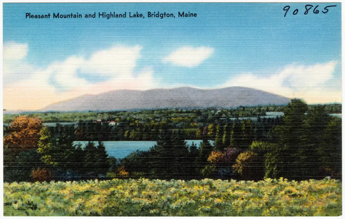
Pleasant Mountain is the tallest peak in southern Maine’s Lakes Region, a long whaleback ridge that rises above Moose Pond on the line between Bridgton and Denmark. At 2,006 feet it is not a tall mountain by White Mountain standards, but it stands alone with no higher ground around it, and that gives the summit a reach that bigger peaks tucked into ranges never get. From the open ledges you look west across Moose Pond to the full wall of the Presidential Range, with Mount Washington anchoring the skyline on a clear day. Turn the other way and the Lakes Region spreads out below: Highland Lake, Long Lake, and the silver sheet of Sebago in the distance.
The mountain has a ridge nearly three miles long with several named summits, the highest being the main summit where a fire tower once stood. The cleared site and the bald ledges below it are the reason people climb here. The western face is also home to the Shawnee Peak ski area (which has carried the Pleasant Mountain name again in recent years), so in winter the lower slopes hum with lift traffic while the hiking trails sleep under snow.
We come back to Pleasant Mountain because it gives a real summit payoff for a half-day of effort. The climbing is steady rather than brutal, the ledges arrive early on the most popular route, and the view is one of the best in the western mountains for the elevation. It is close enough to Portland to be an after-work hike in long June daylight.
Trails and Routes
Pleasant Mountain has a small network of trails that approach the ridge from different sides. Most lead to the main summit eventually, and a couple combine into one of the best ridge traverses in the region.
The Ledges Trail (Moose Trail)
The Ledges is the most popular route and the one most people mean when they say they hiked Pleasant Mountain. It starts from the Mountain Road trailhead on the southeast side and climbs about 1.8 miles to the main summit. The trail earns its name fast, breaking out onto open granite ledges well before the top, so you get views the whole back half of the climb. Round trip from the Ledges lot runs about 3.4 miles with roughly 1,500 feet of gain. This is the route we send first-timers on.
Bald Peak Trail
Bald Peak Trail climbs from the north off Wilton Warren Road to Bald Peak, a subsidiary summit on the ridge, then continues to the main summit. It is a bit longer and quieter than the Ledges, with its own stretches of open rock and a side path to a small waterfall on a tributary brook early in the climb. Many hikers link Bald Peak Trail with the Ledges for a ridge traverse, leaving a car at each end.
Fire Warden’s Trail (Firewarden’s Trail)
The Fire Warden’s Trail is the old service route the warden used to reach the fire tower. It climbs the southwest side and is the most direct line to the summit, but also the steepest and least scenic of the main routes, staying in the woods most of the way. It is a good descent option when you want to drop fast and save your knees the ledge scrambling.
Southwest Ridge Trail
The Southwest Ridge Trail is the longest approach, running up the far southwestern end of the ridge. It is the least traveled trail on the mountain, so it is the one to choose when you want solitude. It connects into the ridgeline trail and on to the main summit, making a long out-and-back or a piece of a bigger traverse.
Sue’s Way
Sue’s Way is a connector trail that ties the Bald Peak side into the network and gives loop options across the ridge. On its own it is short, but it is the link that lets you build a loop instead of an out-and-back, which is how we usually hike the mountain when we have a full morning.
The best way to experience Pleasant Mountain is a point-to-point traverse rather than an out-and-back. Spot a car at the Ledges lot, start up Bald Peak Trail from the north, cross over Bald Peak and the main summit, and descend the Ledges with the lake and Mount Washington in front of you the whole way down. It turns a good hike into a great one and only costs you a short car shuttle.

Getting There
Pleasant Mountain sits just west of Bridgton off Route 302, the main road through the Lakes Region. The Ledges trailhead is on Mountain Road (sometimes signed as Wilton Warren Road on the north end), which leaves Route 302 near the Moose Pond causeway between Bridgton and Fryeburg. The gravel Ledges parking lot is on the right a short way up Mountain Road and is free.
From Portland, plan on about an hour: take Route 302 west through Windham, Raymond, Naples, and Bridgton, and watch for the Moose Pond causeway as you leave town. From Bangor it is a longer haul of roughly two and three-quarter hours. The Bald Peak Trail lot is farther north along Mountain Road, which is what makes the two-car traverse easy to set up.
There are no services at the trailheads themselves, but Bridgton village is minutes away with gas, food, and a grocery store, so it is an easy place to fuel up before or grab a meal after.
The Ledges lot is small and fills early on summer and foliage weekends, especially on bluebird Saturdays in late September and early October. Get there before 9 AM, or start from the Bald Peak side where the lot tends to clear out slower. Late afternoon is also a fine time to go up the Ledges, since the western-facing ledges catch the evening light over Moose Pond.
When to Visit
Summer and fall are the two seasons that shine here. In summer the ledges are warm, the lakes below are full of boats, and the long daylight makes an evening climb easy. Foliage season is the real highlight: the Lakes Region lights up in late September and early October, and from the open summit ledges you look out over a quilt of color with the lakes scattered through it. It is one of the more rewarding fall hikes in southern Maine.
Spring hiking is possible once the snow melts off the ledges, usually by May, but the trails stay muddy and the lower woods fill with black flies through June. Winter is a different story: the mountain is the Shawnee Peak ski area, the hiking lots are not maintained, and the ledges turn to ice. We do not recommend the hiking trails in winter unless you are equipped for ice and cold and know the mountain.
The granite ledges that make this hike so good become genuinely dangerous when wet, icy, or frosted. Smooth rock plus a downhill grade plus rain equals falls every year. After heavy rain, descend by the wooded Fire Warden’s Trail instead of the Ledges, and in shoulder season watch for morning frost lingering on north-facing rock. The summit is also exposed to wind and weather that moves in fast off the mountains to the west, so turn back if a storm builds.
Packing and Tips
This is a moderate half-day hike, but the steady 1,500-foot climb and the open ledges mean you should pack like you mean it. Sturdy footwear with real tread matters more here than on a smooth woods trail, because so much of the route is bare rock that gets slick. Bring plenty of water, since there is none reliable on the ledges, and the exposed rock bakes in summer sun.
The view west is best in the morning before haze builds or in the last hour of light, so time your hike for the ends of the day if you want the cleanest look at Mount Washington. Bring layers for the summit even on warm days, because the wind on the open ridge can cut. And do not forget bug spray from late May through June, when the black flies in the lower hardwoods are at their worst.
Good socks save a hike like this, where the long ledge descent works your feet hard. We hike in merino wool every time.

Best overall hiking socks for Maine trails
When you are done, the Lakes Region gives you plenty of ways to cool off. Sebago Lake and Long Lake are both a short drive away for a swim, and if you want another summit while you are in the area, Douglas Mountain is an easy nearby climb with its own stone tower and lake views. Browse the rest of our hiking guides and lake guides to round out a Bridgton trip.
FAQ
How hard is the Pleasant Mountain hike?
It is a moderate hike. The standard Ledges Trail route is about 3.4 miles round trip with roughly 1,500 feet of elevation gain to the 2,006-foot summit. The climb is steady but not technical, though the open granite ledges require care, especially on the descent and when the rock is wet.
What is the best trail up Pleasant Mountain?
The Ledges Trail is the most popular because it opens onto views early and is the most direct scenic route to the main summit. For the full experience, link the Bald Peak Trail with the Ledges as a point-to-point traverse using two cars, which lets you descend toward Moose Pond and Mount Washington the whole way down.
Can you see Mount Washington from Pleasant Mountain?
Yes. On a clear day the open summit ledges give a wide view west across Moose Pond to the Presidential Range, with Mount Washington anchoring the skyline. The view is cleanest in the morning before haze builds or in the last hour of evening light.
Is Pleasant Mountain dog friendly?
Yes. Dogs are welcome on the trails. The grades are manageable for a fit dog, but bring extra water since there is none reliable on the upper ledges, and keep paws in mind on the long stretches of bare granite, which can get hot in summer sun.
Is Pleasant Mountain the same as Shawnee Peak?
They share the same mountain. The western slopes are the Shawnee Peak ski area, which has carried the Pleasant Mountain name again in recent years. The hiking trails covered here are on the rest of the ridge and are not maintained in winter, when the mountain operates as a ski area.