Maine’s Wildest River Run
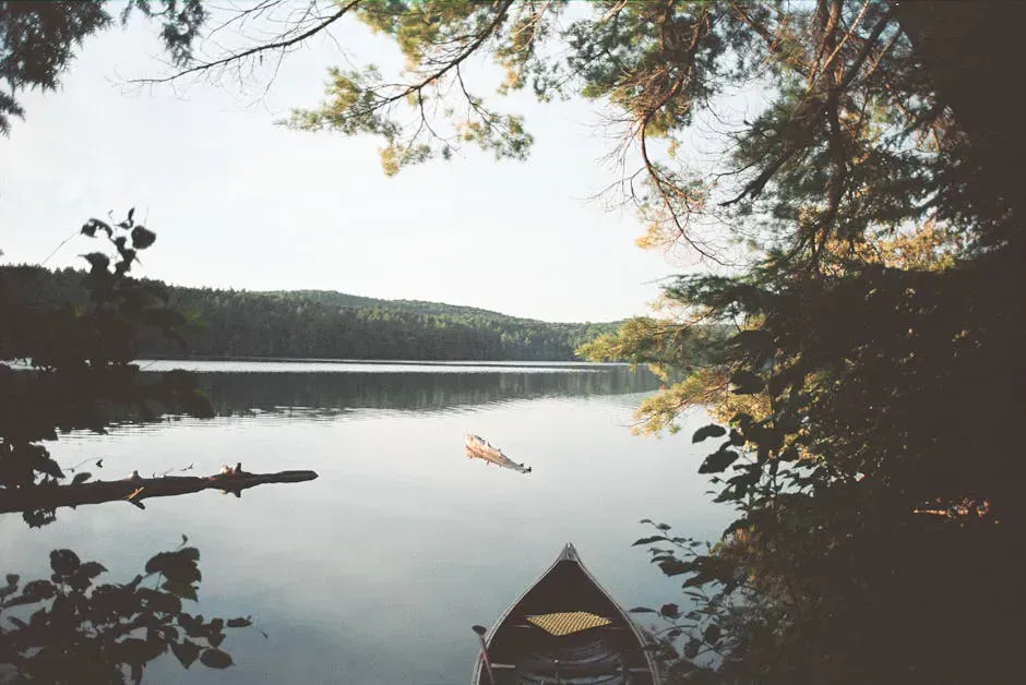
The Machias River is 76 miles of free-flowing water cutting through the remote interior of Washington County in Downeast Maine. From its headwaters at Fifth Machias Lake to the tidewater in the town of Machias, the river passes through virtually no development. There are no dams, no towns, and no paved roads for most of its length. The name comes from the Passamaquoddy word meaning “bad little falls” or “bad run of water,” and that reputation is well earned. This is a challenging, remote, whitewater canoe trip that demands skill, preparation, and respect for the river.
The Machias River Corridor is a state-designated public reserve land stretching along the river’s most remote sections. Primitive campsites with fire rings line the banks, but there are no other facilities. No outhouses, no picnic tables, no cell service. This is backcountry paddling in the truest sense.
The Machias River contains Class II to III+ whitewater depending on water levels. This is not a trip for beginners. Prior whitewater experience is required. The river is completely free-flowing with no dam releases, meaning water levels depend entirely on rainfall and snowmelt. Conditions change rapidly. Cold water, remote location, and lack of cell service make rescue difficult. Go prepared or do not go.
The River
The full 76-mile trip from Fifth Machias Lake to tidewater in Machias takes four to six days, depending on water levels and how much time you spend at camp. The upper sections are the most remote and the most challenging. Below the confluence with the West Branch, the river widens and the rapids ease, though the current remains strong.
The whitewater ranges from Class II riffles and rock gardens to Class III drops with significant waves and technical moves, so come with proper kayaking and paddling gear rated for cold, moving water. Several named rapids test paddlers throughout the trip. Water levels are everything on the Machias. Too low and you are dragging over rocks. Too high and the rapids become powerful and dangerous. The sweet spot is a narrow window, typically in mid to late May, when spring runoff has settled but the river still carries enough water for clean runs through the rapids.
The river corridor is heavily forested with spruce, fir, and hardwoods. Moose, deer, bear, and bald eagles are common along the banks. In spring, the river runs through a landscape that has barely changed since the log-driving era.
The Machias is completely free-flowing, so there is no guaranteed water level. Mid to late May is the most reliable window for adequate water. Check the USGS gauge at Whitneyville (gauge 01021500) before committing to a trip. Canoe outfitters in the area can advise on current conditions and whether the river is runnable.
Trip Planning
Put-in and Take-out
The standard multiday trip starts at Fifth Machias Lake and ends at the Route 1 bridge in Machias or at the tidewater below town. Access to Fifth Machias Lake is via logging roads from Route 9 (the Airline Road). These roads are rough gravel and may require high clearance. A shuttle is necessary, and several outfitters in the region run shuttle services.
Camping
Primitive campsites line the river corridor, spaced roughly every five to eight miles. Most have a fire ring and cleared tent space, but nothing else. Some may have deteriorated between maintenance visits. Bring a camp stove as backup. Water from the river should be filtered or treated, so pack a dependable water filter.
The best campsites are on elevated banks above the river with flat ground and good tree cover. First-come, first-served. On a busy spring weekend, the better sites may be occupied, but the Machias rarely feels crowded.
Outfitters
Several outfitters offer guided trips on the Machias River, which is the recommended approach for anyone unfamiliar with the river. Guided trips include gear, food, shuttle, and an experienced paddler who knows the rapids and campsites.
Sunrise Canoe and Kayak and Canoe the Wild both run Machias River trips in spring. Booking ahead is essential, as the paddling window is short and trips fill.
The Machias River is one of the last undammed rivers of its size in the eastern United States. That makes it ecologically significant and also means the paddling experience is entirely natural. No reservoir fluctuations, no artificial flows. You are at the mercy of the weather, which is part of the appeal.
When to Go
Spring
Mid to late May is the prime window. Snowmelt provides adequate water. Black flies are fierce. Cold water requires preparation.
Summer
Water levels drop too low for most of the river by July. Not runnable in most years.
Fall
Generally too low. Heavy rain events may briefly raise levels, but conditions are unpredictable.
Winter
Frozen and inaccessible. Not a winter trip.
The Machias River has a short season. Mid to late May is the target, with some years extending into early June. Once summer dryness sets in, the river becomes too shallow for loaded canoes. This narrow window makes planning critical. Be flexible with your dates and ready to go when conditions are right.
Packing List
Machias River Trip
- Whitewater canoe or kayak
- PFD/life jacket (worn at all times on the water)
- Helmet for significant rapids
- Dry bags for all gear
- Throw rope
- Camp stove and fuel
- Water filter or purification
- Tent, sleeping bag, sleeping pad
- Full set of dry clothes in dry bag
- Cold-weather layers (May nights are cold)
- Bug head net and bug spray
- First aid kit with river-specific supplies
- Maps of the river corridor
- Satellite communicator or PLB (no cell service)
Getting There
Reaching the Machias River corridor requires driving deep into Washington County. The town of Machias, at the tidewater take-out end, is about 5 hours from Portland and 2.25 hours from Bangor. From Bangor, take Route 9 (the Airline) east through Beddington and Wesley into Washington County. Machias itself sits on US Route 1.
The standard put-in at Fifth Machias Lake is accessed via gravel logging roads branching off Route 9 north of Wesley. These roads are rough, can require high clearance, and are not marked for casual travel. Most paddlers arrange shuttle service through an outfitter like Sunrise Canoe and Kayak or Canoe the Wild rather than attempting the put-in drive in a personal vehicle. The shuttle is worth it simply to avoid leaving your car unattended for a week on a remote logging road.
The take-out is the Route 1 bridge in Machias or the tidewater reach below town, both easy to find off Route 1.
There is no cell service anywhere along the river corridor. Machias has grocery stores, gas, and restaurants. Stock up there before heading out. The river is paddleable only during a narrow window, typically mid to late May, driven entirely by snowmelt. Check the USGS gauge at Whitneyville (01021500) before committing to dates. The water is in the 40s Fahrenheit in May, and a capsized canoe in this remoteness is a survival situation, not an inconvenience.
FAQ
How long does the Machias River trip take?
The full 76-mile trip from Fifth Machias Lake to Machias takes four to six days. Shorter sections are possible, with outfitters offering three-day and four-day trip options.
What class rapids are on the Machias River?
The Machias has Class II to III+ rapids depending on water level. Higher water increases the difficulty. Several named rapids require scouting at higher flows.
When is the best time to paddle the Machias River?
Mid to late May, when spring runoff has settled but the river still carries enough water. The window is narrow, typically two to three weeks. Check the USGS gauge at Whitneyville before committing.
Can beginners paddle the Machias River?
No. The Machias River requires solid whitewater skills, experience with loaded boats in current, and comfort in a remote setting with no rescue options. Beginners should consider guided trips with an experienced outfitter.
Is there cell service on the Machias River?
No. There is no cell service for the vast majority of the river corridor. A satellite communicator or personal locator beacon is strongly recommended for safety.