The Ridge Walk to Acadia’s Highest Point
The Cadillac South Ridge Trail is the longest and most rewarding hiking route to the summit of Cadillac Mountain, the highest point on the North Atlantic coast at 1,530 feet. While most visitors drive or take the shorter North Ridge Trail to the top, the South Ridge offers something no other route can match: nearly two miles of continuous above-treeline ridge walking with expanding views in every direction, a gradual and steady climb that feels more like a mountain traverse than a simple summit bid.
At 7 miles round trip with 1,530 feet of elevation gain, this is not Acadia’s shortest day out. But the grade is consistently moderate, there are no technical scrambles, and the trail is well-marked with cairns and blue paint blazes across the open rock. The South Ridge is the trail that makes you feel like you have truly earned the famous summit view, rather than having it handed to you from a parking lot.
From approximately October 7 through March 6, Cadillac Mountain is the first place in the United States to receive the morning sun. Hikers who set out before dawn from the South Ridge trailhead, headlamps bobbing in the dark, arrive at the summit for a sunrise that is genuinely one of the great natural spectacles in the eastern United States. The sun rises directly out of the Atlantic Ocean, painting the sky in shades of orange, pink, and gold.
The Trail
The South Ridge trailhead is located on Route 3, about 1.5 miles south of the Blackwoods Campground entrance. A small pulloff on the west side of the road provides parking for 10 to 15 cars. The trailhead is marked with a wooden post and a small sign that is easy to miss if you are not looking for it.
The trail enters the forest and climbs gently through a canopy of spruce, birch, and oak. The lower section gains elevation gradually, following a well-worn path over roots and rocks. After about a mile, the forest begins to thin and the first views appear through gaps in the trees. Pitch pines, stunted by wind and thin soil, become the dominant trees as you gain elevation.
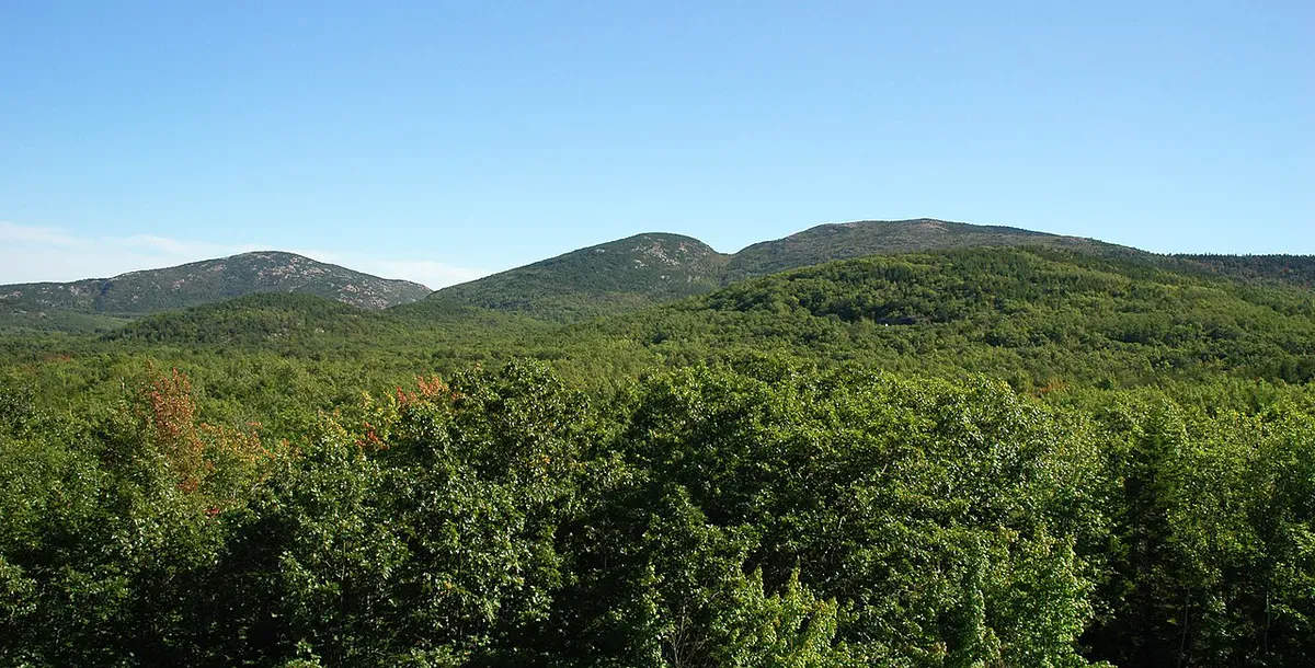
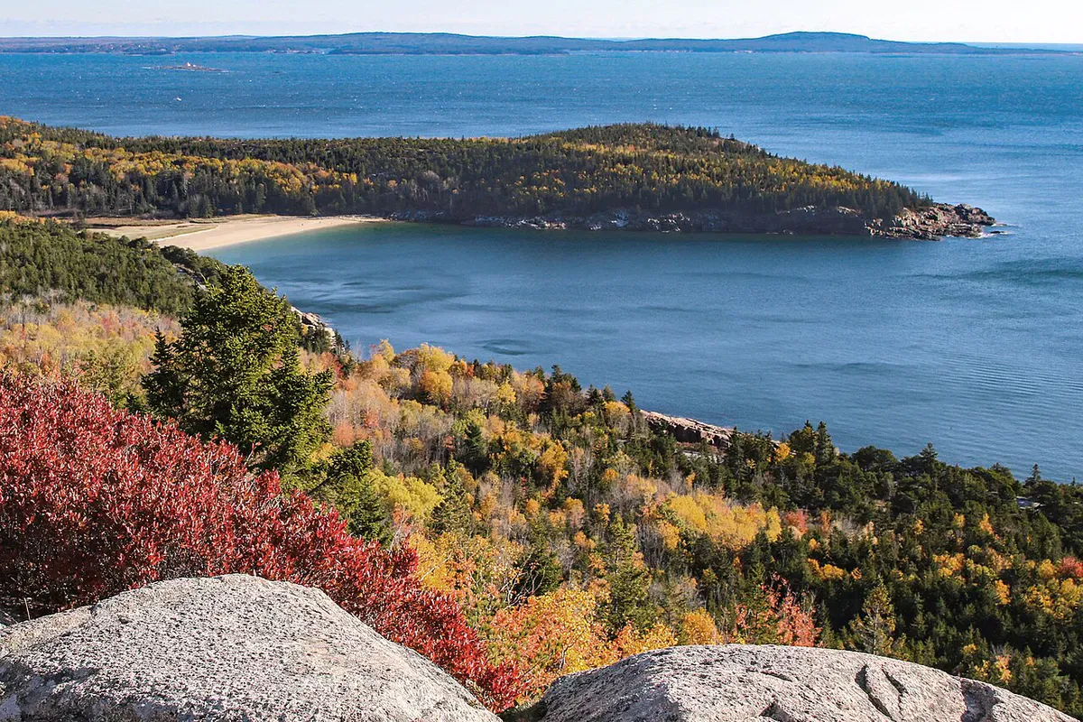
At approximately 1.5 miles, the trail breaks above treeline onto open granite. This is where the character of the hike changes completely. The ridge stretches ahead of you, a long spine of bare pink granite rising gradually toward the summit. Cairns spaced every 50 to 100 feet mark the route across the rock. On clear days, the visibility is extraordinary: Penobscot Bay to the southwest, the Cranberry Isles offshore, Frenchman Bay to the northeast, and the peaks of Acadia’s interior spreading in all directions.
The ridge walk itself covers roughly 1.5 miles from treeline to summit. The grade is gentle, rarely steep enough to require scrambling. The exposed rock is Cadillac granite, a coarse-grained pink rock that provides excellent friction for hiking boots when dry. Low-growing blueberry, mountain cranberry, and three-toothed cinquefoil grow in the cracks between the rock slabs.
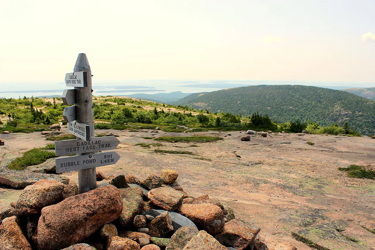
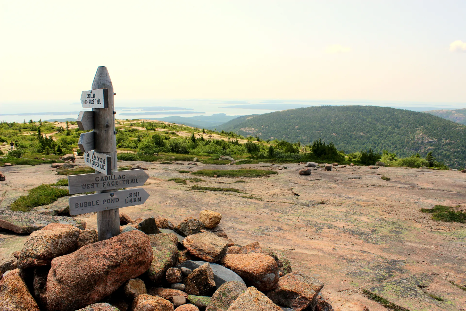
Eagles Crag, a minor highpoint about two-thirds of the way along the ridge, provides an excellent rest stop with views south toward the Cranberry Isles. From Eagles Crag, the final push to the summit follows the ridge through one more dip before the final gentle ascent to the summit, where you join the crowds who drove up and hiked the shorter North Ridge.
For the sunrise experience, start hiking about 90 minutes before sunrise. The trail is well-cairned and navigable by headlamp. Arrive at the summit 15 to 20 minutes before sunrise to stake out a spot on the eastern-facing rocks. Bring warm layers because the summit is cold and windy before dawn, even in summer.
What You’ll See
The above-treeline ridge walk is the main attraction. The continuous open rock provides uninterrupted views that shift and expand with every step. To the south, Otter Cove, Seal Harbor, and the Cranberry Isles are spread below. To the east, the Atlantic Ocean stretches to the horizon. To the west, the forested interior of Mount Desert Island is dotted with lakes: Eagle Lake, Jordan Pond, and Bubble Pond are all visible.
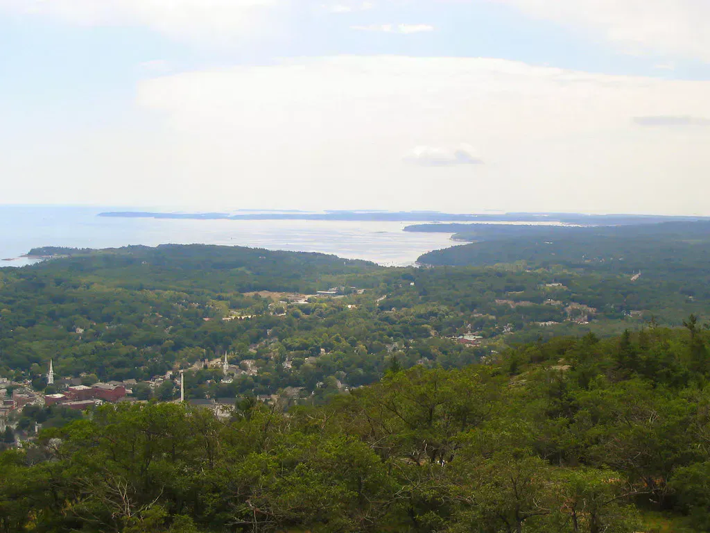
The summit panorama is justifiably famous. On a clear day, you can see roughly 60 miles in every direction. The Schoodic Peninsula and the Downeast coast extend to the east. The Camden Hills are visible to the southwest. Mount Katahdin, Maine’s highest peak, is theoretically visible on the clearest days, though the 120-mile distance makes this a rare treat. Below the summit, Bar Harbor sits at the edge of Frenchman Bay, the town’s waterfront clearly visible.
The open rock hosts a surprising amount of wildlife. Northern harriers hunt the ridgeline in migration season. Peregrine falcons pass through in fall. Ravens are year-round residents. In August, the blueberry bushes along the ridge produce abundant fruit, and you can graze your way to the summit. Look for painted lady and monarch butterflies in late summer as they migrate south along the coast.
The South Ridge is fully exposed above treeline for nearly 2 miles. Lightning strikes are a real hazard during thunderstorms. If you see or hear a storm approaching, descend below treeline immediately. Do not wait. The open granite also makes navigation difficult in fog, so carry a map and compass or GPS. In winter, the ridge is severely wind-exposed with dangerous wind chill.
When to Go
Spring
Ice and snow can linger on the ridge into May. Late spring offers wildflowers on the lower trail and uncrowded conditions above treeline.
Summer
Long days and dry rock make this the ideal season. Blueberries ripen in August. The summit will be crowded, but the ridge walk is solitary.
Fall
Spectacular foliage viewed from above, clear dry air, and cooler temperatures. The sunrise is at a more reasonable hour than summer. Peak season for the classic Cadillac sunrise.
Winter
Experienced winter hikers can summit via the South Ridge. The road to the summit is closed, making this the only route. Expect ice, severe wind, and limited daylight.
Getting There
The South Ridge trailhead is on Route 3, about 3 miles south of Bar Harbor. Drive south on Route 3 past the Sieur de Monts entrance and the Blackwoods Campground. The small trailhead parking pulloff is on the right (west) side of the road, about 1.5 miles south of the Blackwoods entrance. Watch for the small trail sign.
Parking is limited to about 10 to 15 cars. For sunrise hikes, arrive early. On peak summer mornings, the pulloff can fill before dawn. No shuttle service reaches this trailhead.
The South Ridge is the locals’ route up Cadillac. While crowds drive the auto road and hike the North Ridge, experienced Acadia hikers take the South Ridge for the superior hiking experience and the solitude of the long ridge walk. On a busy August Saturday, you might pass only a handful of other hikers on the ridge before joining hundreds at the summit.
Packing List
- Hiking boots with good grip for granite
- 2 liters of water (no water on the ridge)
- Lunch and snacks for the long ridge walk
- Rain jacket and extra layer (exposed ridge)
- Sunscreen and hat
- Headlamp if hiking for sunrise
- Warm layers for pre-dawn summit arrival
- Camera for panoramic views
- Map and compass or GPS (fog navigation)
- Acadia National Park pass
FAQ
How long does the Cadillac South Ridge Trail take?
Plan for 4 to 5 hours round trip at a moderate pace, including time on the summit. Strong hikers can complete it in 3 to 3.5 hours.
Is this the best trail for sunrise on Cadillac?
For hikers, yes. The South Ridge is the preferred route for sunrise because the trailhead is accessible without a vehicle reservation for the auto road. Plan to start 90 minutes before sunrise.
Do I need a vehicle reservation for the auto road?
Not if you are hiking. The South Ridge trailhead is on Route 3, not on the auto road. You need a standard Acadia park pass but no vehicle reservation.
Is the South Ridge harder than the North Ridge?
It is longer (7 miles vs 4.4 miles) but the grade is more gradual. The North Ridge is shorter and steeper. The South Ridge has more above-treeline walking and is generally considered the more scenic route.
Can I bring my dog?
Yes, dogs are allowed on leash on the South Ridge Trail. Be aware that the long exposed ridge can be hot in summer and cold in winter, so plan accordingly for your dog.