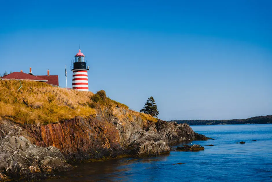
The Darkest Cliffs in Maine
The Quoddy Head Coastal Trail follows 2 miles of cliff edge at the easternmost point of the continental United States, where black volcanic rock drops 150 feet straight into the Bay of Fundy. These are not the pink granite headlands of Acadia or the gray ledges of the midcoast. The rock here is gabbro, a dark volcanic formation dating to the Silurian Age, roughly 430 million years ago, when magma rose from the ocean floor and cooled into the dense, dark stone that now forms the coast. The cliffs are genuinely black, strikingly so against the white foam of the surf below and the blue water beyond. On a foggy day, which is most days in summer, the dark walls emerge from the mist like something out of a different landscape entirely.
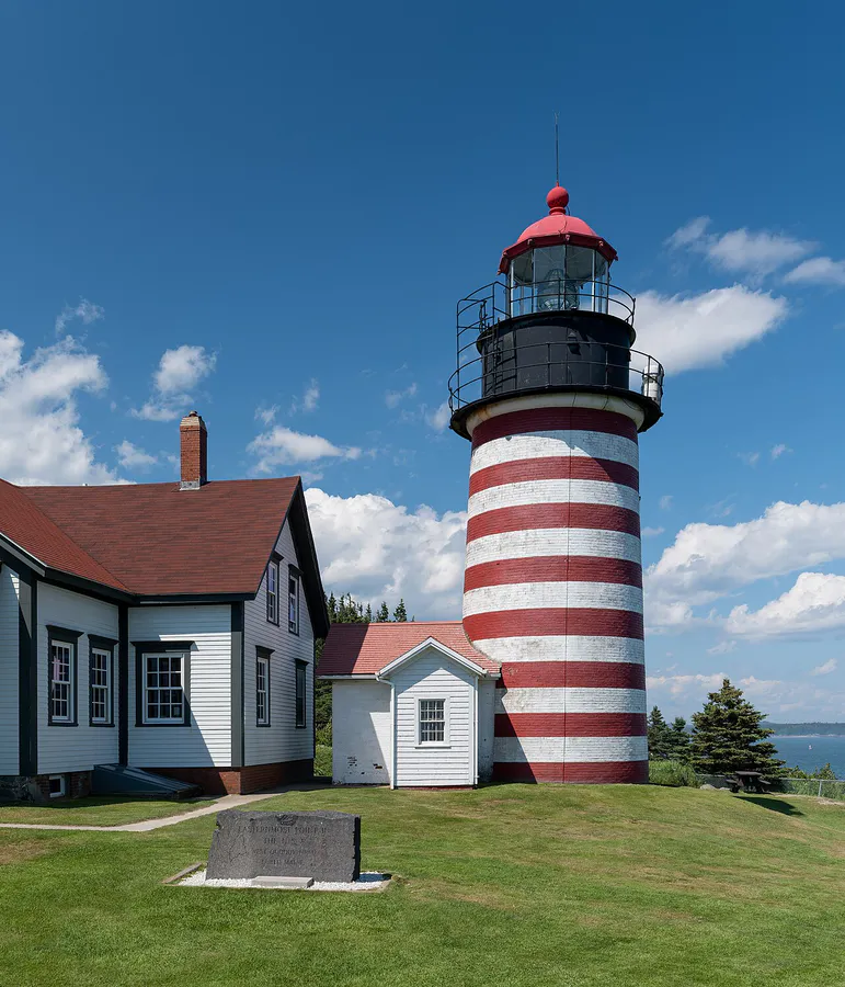
The trail begins at the West Quoddy Head Lighthouse within Quoddy Head State Park and runs south along the coast through dense coastal spruce forest and along exposed cliff edges. It is a 4-mile round trip to Green Point and back, with three major geological features along the way that make this one of the most dramatic coastal hikes in the eastern United States.
The Three Highlights
Gulliver’s Hole: About a mile south of the lighthouse, the trail passes Gulliver’s Hole, a dramatic chasm in the cliff face where the ocean has carved a narrow inlet into the gabbro. The walls of the chasm rise vertically on both sides, and the ocean surges in and out with each wave, sending spray up the dark walls. The formation was created by the erosion of a vertical fault line in the rock, where a weaker band of stone was carved away while the surrounding gabbro remained. Standing at the edge and looking down into the chasm is vertiginous.
High Ledge: The signature viewpoint of the trail, a 150-foot bluff that provides the most expansive panorama. From High Ledge, you look south along miles of coastline, east across the Bay of Fundy to the towering red cliffs of Grand Manan Island in New Brunswick, Canada, and down to the waves breaking against the base of the black cliffs below. On clear days, the view extends to the open Atlantic. This is the highest point on the trail and the place where the scale of the cliffs is most apparent.
Green Point: The turnaround point for the standard hike, a ledge outcropping where you can watch the surging tides and pounding surf of the Bay of Fundy. Carrying Place Cove, with its sand beach, is nearby. The tidal range here can exceed 20 feet, one of the highest in the world, driven by the funneling effect of the Bay of Fundy.
The Geology
The black cliffs of Quoddy Head are composed of gabbro, an intrusive igneous rock chemically similar to basalt but with larger mineral crystals because it cooled slowly underground rather than erupting at the surface. The gabbro at Quoddy Head formed during the Silurian period when Maine was at the edge of a closing ocean basin and volcanic activity was widespread. Over hundreds of millions of years, the overlying rock eroded away to expose the gabbro at the surface, and the relentless action of the Bay of Fundy’s extreme tides carved the cliffs we see today.
The dark color comes from the rock’s mineral composition: high concentrations of iron and magnesium-rich minerals like pyroxene and olivine, in contrast to the quartz and feldspar that give granite its lighter color. This is why the Quoddy Head cliffs look so different from the coastline at Acadia just 100 miles to the southwest.
Wildlife Along the Trail
The Bay of Fundy’s nutrient-rich waters attract marine life visible from the clifftops. Harbor seals haul out on the ledges below, particularly at low tide. Harbor porpoises are common in the waters offshore, their small dorsal fins breaking the surface as they roll. In late summer, minke whales and occasionally humpback whales feed in the bay, visible from High Ledge with binoculars.
Seabirds include razorbills, black guillemots, common eiders, and various gull species. Bald eagles patrol the cliffs, and peregrine falcons have been observed hunting along the headlands. The spruce forest along the trail supports boreal birds including boreal chickadees and a variety of warblers.
When to Go
Summer
Best weather for hiking. Fog is very common, especially in the morning. Whale watching from the cliffs is possible in July and August. Bog flowers bloom along the trail.
Fall
Fog decreases and visibility improves. The surrounding spruce forest stays green but inland hardwoods turn color. Fewer visitors. Storm surf can be dramatic.
Spring
Park opens May 15. Cool and often foggy. Migrating birds pass through. Trails can be muddy.
Winter
Park officially closed but trails are accessible. Winter storms produce powerful surf. Very cold and windy. The cliffs are at their most dramatic in winter light.
Getting There
Quoddy Head State Park is located at the end of South Lubec Road, about 4 miles south of the village of Lubec. The Coastal Trail begins at the parking area near the West Quoddy Head Lighthouse. From Bangor, the drive is about 2 hours and 15 minutes via Route 1A and Route 1 to Route 189. From Portland, about 4 hours.
Park entrance fees are $4 for Maine residents and $6 for non-residents, collected at a self-service station. Cash or check only.
GPS coordinates for the trailhead: 44.8150, -66.9510
Quoddy Head Coastal Trail Essentials
- Sturdy hiking boots with ankle support
- Layers and windbreaker (coastal wind and fog)
- Binoculars for wildlife and island views
- Camera with waterproof protection
- Bug spray (summer, especially near the bogs)
- Water and snacks (no vendors in the park)
- Cash for entrance fee (no cards accepted)
- Offline maps (spotty cell service)
FAQ
How long does the Quoddy Head Coastal Trail take?
The 4-mile round trip takes 2 to 3 hours at a moderate pace, depending on how long you spend at the viewpoints. Allow extra time for photography and wildlife watching.
Why are the cliffs black at Quoddy Head?
The cliffs are composed of gabbro, a dark volcanic rock rich in iron and magnesium minerals. The rock formed during the Silurian period about 430 million years ago from slowly cooling underground magma.
Can I see whales from the Quoddy Head cliffs?
In late summer, minke and occasionally humpback whales feed in the Bay of Fundy and can be spotted from High Ledge with binoculars. Harbor porpoises are more common and visible throughout the season.
Is the trail safe in fog?
The trail is marked but the cliff edges are unprotected. In heavy fog, visibility drops to a few feet and the cliff edge can be difficult to judge. Exercise extreme caution. Consider postponing if fog is very dense.
What is Gulliver's Hole?
A dramatic narrow chasm in the cliff face about a mile south of the lighthouse, carved by ocean erosion along a vertical fault line in the gabbro. The ocean surges in and out of the chasm with each wave.