The Other Falls on Moxie Stream
Everyone knows about Moxie Falls. The 90-foot plunge with the boardwalk overlook draws crowds all summer. What most visitors miss is the cascade downstream, where Moxie Stream continues its descent through the gorge toward the Kennebec River. Moxie Stream Falls is smaller, harder to reach, and receives a fraction of the foot traffic. That is exactly why it is worth finding.
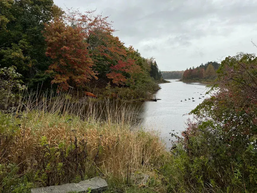
The cascade sits roughly a kilometer above where Moxie Stream empties into the Kennebec. The stream drops through a series of ledges and chutes, carving through the same dark slate that makes the main falls so striking. The setting is wilder and less developed than the famous overlook upstream. There is no boardwalk, no railing, and most days, no other people.
There is no maintained trail to Moxie Stream Falls. Access requires scrambling along the stream bank and navigating steep, slippery terrain. The gorge walls are unstable in places. This is not a beginner outing. Do not attempt it alone or without sturdy footwear and basic navigation skills.
Getting to the Falls
From the Moxie Falls parking area on Moxie Pond Road, most visitors walk the boardwalk trail to the main falls. To reach the downstream cascade, you need to continue past the main overlook and follow the stream downhill. There is no marked trail for this section. You are picking your way along the gorge rim and occasionally descending to the stream level where the terrain allows it.
The distance from the main Moxie Falls overlook to the downstream cascade is roughly half a mile, but the going is slow. The terrain is steep, rocky, and often slippery, so sturdy hiking boots with ankle support are not optional on this off-trail scramble. Fallen trees and thick brush block parts of the route. Allow an hour to reach the lower falls from the main overlook, and an hour to return.
An alternative approach comes from downstream, following Moxie Stream upstream from a point closer to the Kennebec River. This route involves less elevation change but more bushwhacking through dense forest. Neither route is easy, which is why this cascade stays quiet.
The Falls
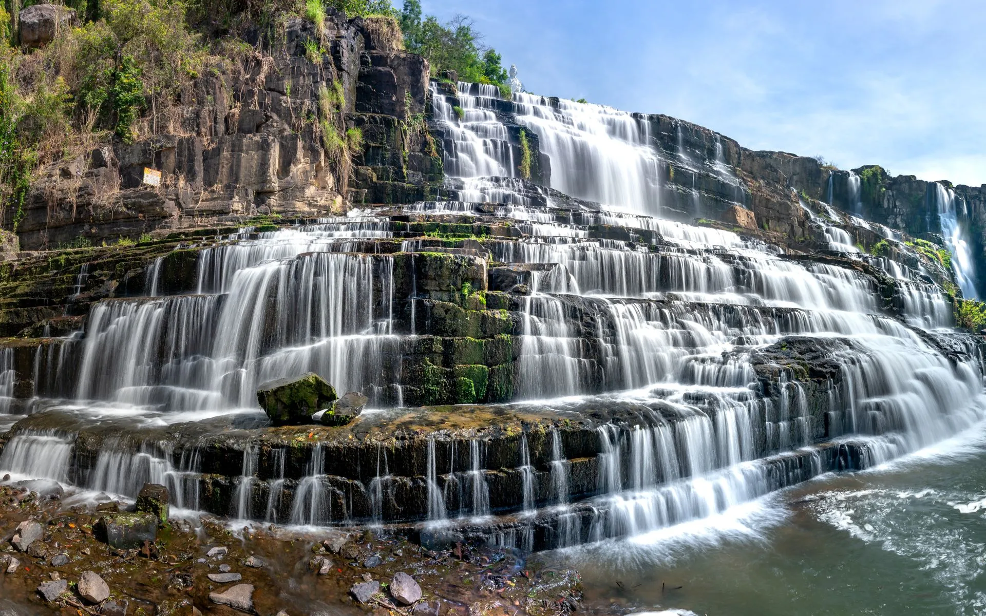
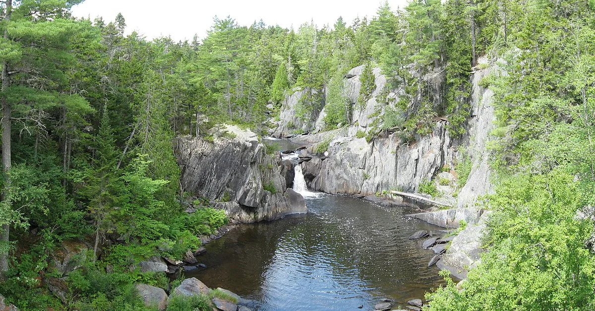
Moxie Stream Falls is not a single vertical drop but a sustained series of cascades and chutes spread over roughly 30 feet of elevation change. The stream squeezes through narrow gaps in the slate, fans out across wider ledges, and drops into pools carved into the bedrock. The rocks are dark and the gorge is shaded by the surrounding forest, which creates a cool, enclosed atmosphere even on hot summer days.
The individual drops range from 3 to 10 feet, and the connecting slides and chutes add variety to the scene. In spring, the combined flow from Moxie Pond upstream pushes serious volume through this section, and the cascades are loud and powerful. By late summer, the flow calms and the pools become more accessible.
Brook trout hold in the deeper pools, and the fishing can be productive if you are willing to work for it. The thick brush and steep banks make casting difficult, but the fish see very little pressure.
See the main Moxie Falls first via the boardwalk trail, then continue downstream to explore the lower cascade. This way you get Maine’s most famous waterfall and one of its most overlooked in a single outing. Budget at least three hours for the combined trip.
When to Visit
Spring
Peak water flow from snowmelt. The cascades are at their most powerful. The gorge is slippery and the route is more hazardous.
Summer
Lower water makes the rocks more accessible. Warmer weather for scrambling. Bugs can be thick in June.
Fall
Foliage color in the gorge. Cooler temperatures. Moderate water flow.
Winter
Accessible with snowshoes, but the gorge is treacherous when icy. Not recommended for most visitors.
Spring offers the most dramatic water but the most hazardous conditions. Summer is the safest time to explore the gorge, with lower water levels exposing more rock and creating stable footing, though black flies in June make bug and tick protection essential for the bushwhack. Fall brings color to the hardwoods lining the gorge rim.
If you are spending a full day in the area, combine the Moxie Stream waterfalls with a whitewater rafting trip on the Kennebec River. Several outfitters in The Forks run daily trips from May through October. A morning at the falls and an afternoon on the river makes a full day of water adventures.
Practical Notes
There are no fees or permits required. Use the same parking area as for Moxie Falls on Moxie Pond Road. There are no restrooms at the trailhead.
Dogs should be left behind for this one. The terrain is too steep and unpredictable for most dogs, and the gorge presents real hazards.
Cell service is nonexistent at the falls and along the route. Tell someone your plans before you go.
Packing List
Moxie Stream Falls Trip
- Sturdy hiking boots with good ankle support
- Water (at least 1 liter)
- Bug spray (essential May through July)
- Camera
- First aid kit
- GPS device or topo map
- Rain jacket
Getting There
Moxie Stream Falls is in Moxie Gore, Somerset County, downstream of the well-known Moxie Falls. The Forks is the nearest town with services, including outfitters for Kennebec whitewater rafting, restaurants, and fuel. Plan your visit from there.
Use the same parking area as Moxie Falls, off Moxie Pond Road. From the parking lot, walk the standard boardwalk trail toward the main overlook. To reach the downstream cascade, continue past the main overlook and follow the stream downhill. There is no marked trail, no signs, and no railings on this section. You are picking your way along the gorge rim and descending to stream level where the terrain allows.
The distance from the main Moxie Falls overlook to the downstream cascade is roughly half a mile, but the going is slow. Terrain is steep, rocky, and slippery, with fallen trees and thick brush blocking parts of the route. Allow an hour each way from the main overlook. GPS coordinates for Moxie Stream Falls are approximately 45.3550, -69.9350.
An alternative approach comes from downstream, following Moxie Stream upstream from a point closer to the Kennebec River. This route involves less elevation change but more bushwhacking. Cell service is nonexistent. Do not attempt this trip alone or without sturdy footwear and basic navigation skills, the gorge walls are unstable in places and the terrain is genuinely hazardous.
FAQ
Where is Moxie Stream Falls?
Moxie Stream Falls is downstream of the famous Moxie Falls, roughly half a mile below the main overlook in the Moxie Stream gorge. It is in Moxie Gore, Somerset County.
Is there a trail to Moxie Stream Falls?
No. There is no maintained trail. Access requires scrambling along the gorge rim and descending to the stream where possible. Navigation skills and sturdy footwear are required.
How does Moxie Stream Falls compare to Moxie Falls?
Moxie Falls is a single 90-foot plunge with a developed boardwalk trail. Moxie Stream Falls is a series of smaller cascades spread over 30 feet, with no trail and very few visitors. They are different experiences on the same stream.
Can you fish at Moxie Stream Falls?
Yes. The pools hold brook trout and see very little fishing pressure. A Maine fishing license is required. The thick brush makes casting challenging.
Is Moxie Stream Falls safe to visit?
The route to the falls involves steep, slippery terrain with no maintained trail. The gorge walls can be unstable. It is safe for experienced hikers with good footwear and caution, but not recommended for beginners, young children, or dogs.