Maine’s Highest Peak and the End of the Appalachian Trail
Baxter Peak sits at 5,267 feet, the highest point in Maine and the northern terminus of the 2,190-mile Appalachian Trail. For thru-hikers, the wooden sign on the summit is the finish line of a journey that started months earlier in Georgia. For day hikers, the Hunt Trail is one of the most demanding climbs in the Northeast and one of the most rewarding.
The trail starts at Katahdin Stream Campground in Baxter State Park and climbs through forest, then up the Hunt Spur, a steep boulder scramble where iron rebar handholds are bolted into the granite, before flattening out across the Tableland and crossing Thoreau Spring on the final push to Baxter Peak. Round-trip distance and elevation gain are substantial. Park staff classify every Katahdin trail as the most strenuous category on the mountain. Most day hikers spend eight to ten hours round trip.
The Parking Reservation System
You cannot just drive to the trailhead and start hiking. Baxter State Park caps parking at every trailhead, and a parking reservation is required to hike Katahdin from spring through fall. Reservations are released in advance through the park and the popular summer dates sell out within hours of release. Plan months ahead.
The reservation system is the single biggest planning constraint for hiking Katahdin. Check the official Baxter State Park website for the current year’s release schedule, day-use fees, and reservation rules. Day-use is free for Maine residents and $20 per vehicle for non-residents (2025 rate).
If you cannot get a Katahdin Stream parking reservation, the alternative is to camp inside the park the night before. Campers staying at Katahdin Stream, Abol, or other in-park campgrounds get trailhead access without needing a separate day-use reservation.
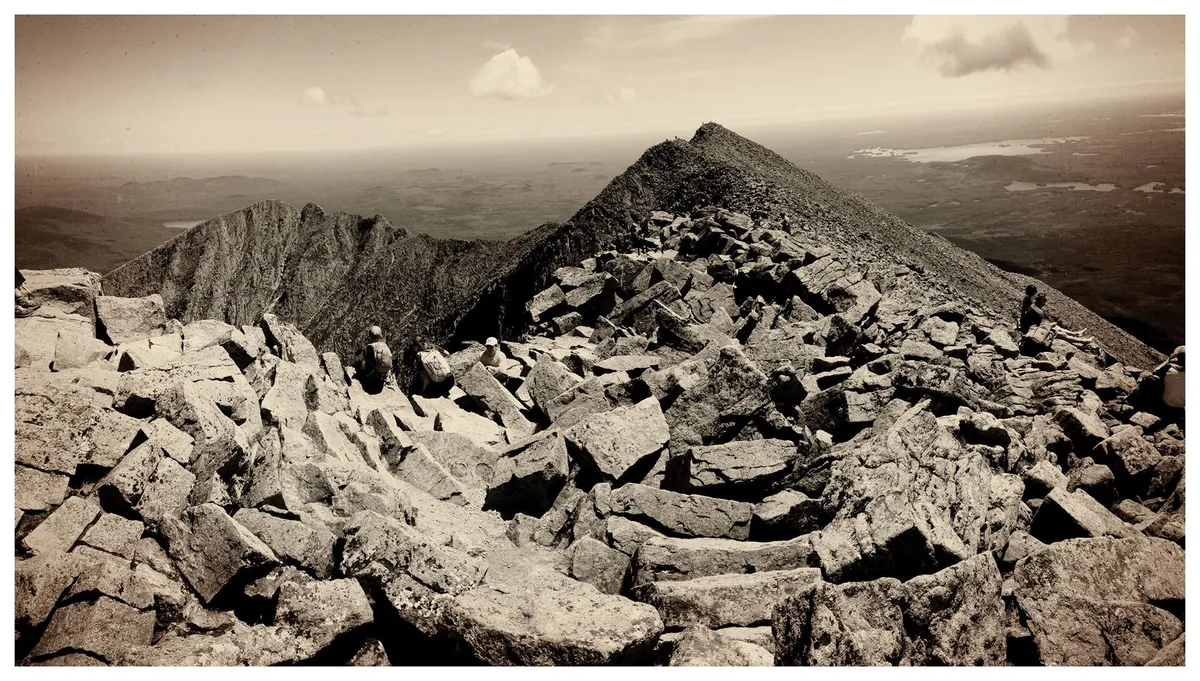
The Hunt Spur
The Hunt Spur is the section that defines the climb. After a few forested miles, the trail breaks above treeline and turns into a near-vertical scramble up bare granite blocks. Iron rungs and rebar are placed at the worst spots, but you are using your hands the whole way up. It is exposed, the footing is committing, and any moisture on the rock makes it dramatically harder.
This is where most hikers learn whether they should be on the mountain that day. If the weather is questionable, the spur is slick, or you are already tired from the lower trail, turning around at the base of the spur is the right call.
The Tableland and Thoreau Spring
Above the Hunt Spur, the trail emerges onto the Tableland, a broad alpine plateau that feels like another world. The pitch eases, the wind picks up, and Baxter Peak appears in the distance across an expanse of fragile alpine vegetation. Stay on the marked trail. The plants up here grow back at a rate measured in decades.
Thoreau Spring sits about a mile from the summit and is named for Henry David Thoreau, who climbed Katahdin in 1846. From the spring it is a steady grind to the summit cairn and the famous wooden sign.
When to Go
Spring
Trails open as snow melts, typically late May. Cold, wet, and ice may linger on the upper mountain.
Summer
Peak hiking season. Long days, stable weather windows, but trailhead parking sells out months in advance.
Fall
Cool air, fewer bugs, foliage in the lowlands. Weather windows are shorter and the mountain gets cold fast.
Winter
Park access is limited and Katahdin in winter is a serious mountaineering objective, not a day hike.
The best windows are mid-July through early September for stable weather, and late September for foliage and cool air. Always check the park’s daily trail status board on the morning of your hike. Park staff post a Class I, II, III, or IV rating that reflects current conditions, and Class IV closes Katahdin to all hiking.
Pack For a Mountain, Not a Hike
Katahdin Day Hike Essentials
- At least 3 liters of water per person
- Calorie-dense food for 8 to 10 hours on the trail
- Waterproof shell jacket and warm midlayer
- Hat and gloves (the summit is much colder than the trailhead)
- Headlamp with fresh batteries
- Sturdy boots with grippy soles
- Map and compass or downloaded offline map
- Basic first aid kit
- Sun protection (the Tableland is fully exposed)
The summit is routinely 20 to 30 degrees colder than the parking lot, and weather can change in minutes. People underestimate this mountain every year and pay for it. Pack like you are heading into the alpine because you are.
Safety
Start before sunrise. The trail register at Katahdin Stream Campground is open all night, and the early start gives you a margin if anything slows you down on the descent. Locals on the mountain at 5 a.m. have already accepted that this is a long day.
Lightning on the Hunt Spur and Tableland is dangerous. There is no shelter above treeline. If you see or hear thunderstorms building, turn around. The summit will still be there next year.
The descent is harder on the body than the climb. The same boulder field you scrambled up in the morning is much more punishing on tired legs and knees. Plan for the descent to take nearly as long as the ascent, and pace yourself accordingly.
Getting There
Katahdin Stream Campground sits inside Baxter State Park, accessed through the Togue Pond Gate near Millinocket. From Millinocket the drive to the trailhead is roughly an hour on the park’s gravel Tote Road. Cell service ends well before you reach the gate.
The park’s official information is the only source you should trust for current rules, fees, and reservation procedures. Things change year to year. Always check baxterstatepark.org before you go.
FAQ
How hard is the Hunt Trail?
It is one of the hardest day hikes in the Northeast. Baxter State Park rates every Katahdin trail in their highest difficulty category. Plan on 8 to 10 hours round trip, with sustained scrambling on the Hunt Spur and an exposed alpine traverse on the Tableland.
Do I need a reservation to hike Katahdin?
Yes. Baxter State Park requires a day-use parking reservation for Katahdin Stream Campground (the Hunt Trail trailhead) and other trailheads in season. Reservations open in advance and sell out quickly. Campers staying overnight inside the park get trailhead access included with their site.
What time should I start?
Before sunrise is standard. Park rules require you to be off the summit by a certain time and to sign in at the trailhead register. Starting at first light (or earlier) gives you the best weather window and a margin for the long descent.
Are dogs allowed?
No. Dogs and other pets are not permitted in Baxter State Park.
Is the Hunt Trail the same as the Appalachian Trail?
Yes. The Hunt Trail is the final 5 miles of the Appalachian Trail, ending at the wooden summit sign on Baxter Peak. Northbound thru-hikers finish their journey here.
For a longer Baxter trip, see our guide to camping at Baxter State Park and the wilder country around Katahdin Woods and Waters.