A Western Maine Valley Paddle
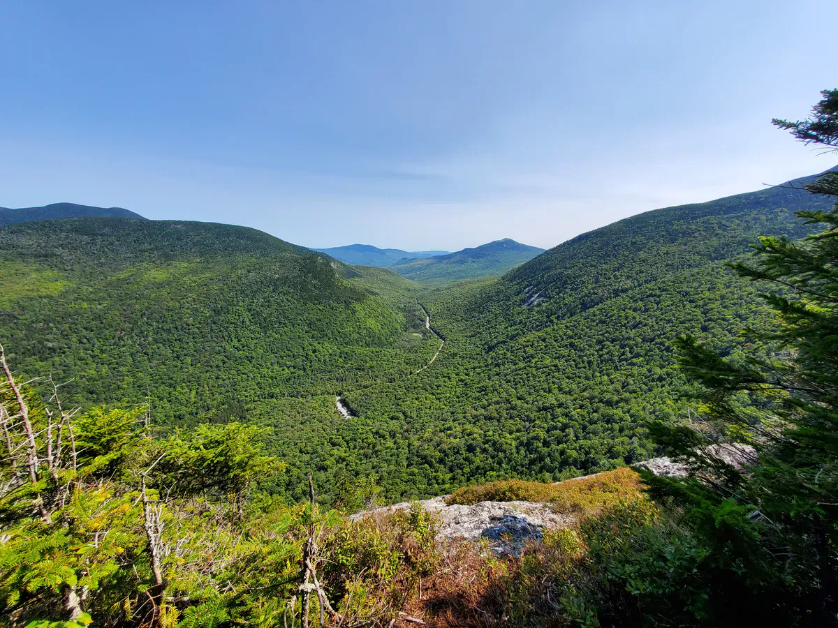
The Androscoggin River flows through one of western Maine’s most scenic corridors, cutting between forested ridges and open farmland as it winds from Bethel downstream toward Rumford. The roughly 22-mile stretch between these two towns offers a mix of flatwater cruising and Class I-II rapids that keeps things interesting without demanding expert skills. Mountain views frame the river on both sides, and on a clear summer morning the water reflects the ridgeline of the Mahoosuc Range to the north.
This section of the Androscoggin has cleaned up dramatically since the 1960s, when it was considered one of the most polluted rivers in America. Today it supports thriving populations of smallmouth bass, brook trout, and bald eagles. The recovery is one of New England’s great environmental success stories, and paddling the river now you would never guess its history.
Most paddlers put in at the public boat launch in Bethel near the Route 2 bridge and take out at one of several access points downstream. You can break the trip into shorter day sections or paddle the full distance as a long day on the water.
The Androscoggin runs high and fast during spring snowmelt, typically April through mid-May. Water temperatures are cold and the current is strong enough to make Class I rapids feel like Class II. Check USGS gauge readings at Bethel before launching in spring. The river is also affected by upstream dam releases from the Rangeley Lakes chain, which can raise water levels unexpectedly.
Paddling the River
The Bethel-to-Rumford corridor breaks naturally into three sections. The upper stretch from Bethel to Hanover (about 8 miles) is the most scenic, with views of Sunday River Ski Resort and the Mahoosuc Range. The river here alternates between gentle riffles and long flatwater pools. Class I rapids appear at a few gravel bars where the river narrows, but nothing that requires scouting.
The middle section from Hanover to the Rumford Point area adds a few more riffles and one notable Class II rapid near the old dam site below Hanover. This rapid has a clear tongue and a straightforward line, but at higher water levels the waves build and less experienced paddlers should scout from shore. Make sure your kayaking gear is sorted for moving water before you launch.
The final stretch into Rumford passes through a narrower valley with steeper banks. The town of Rumford itself sits below a significant waterfall and dam, so plan your take-out well upstream of the falls. The public access at Rumford Point is the standard endpoint.
The 8-mile stretch from Bethel to Hanover makes the best standalone day trip. It has the best mountain scenery, consistent Class I water to keep things fun, and multiple gravel bars for lunch stops. Allow four to five hours for a relaxed pace with fishing and swimming breaks.
Fishing the Androscoggin
The river’s environmental comeback has turned it into one of western Maine’s best warmwater fisheries. Smallmouth bass are the main draw, and they are plentiful from Bethel all the way downstream. Fish concentrate around rocky ledges, submerged boulders, and the eddies below riffles. Topwater action is excellent in summer mornings and evenings, so bring fishing gear you can cast from the boat.
Brook trout hold in the cooler tributary mouths that feed into the main stem, especially the Bear River confluence near Newry and several unnamed feeder streams between Bethel and Hanover. Brown trout show up occasionally in deeper pools.
Fishing pressure is moderate. You will not have the river to yourself on a Saturday in June, but compared to the Rangeley region or the Kennebec, the Androscoggin sees far fewer anglers relative to the quality of the fishing.
The stretch just below the Bethel boat launch has a series of submerged ledges that hold bass all summer. Local anglers work these ledges with tube jigs and crawfish imitations. Look for the darker water where the bottom drops from gravel to rock. Early morning and late evening produce the most consistent topwater blowups.
When to Go
Spring
High water provides exciting rapids. Cold water requires wetsuits. Best for experienced paddlers in May.
Summer
Warm water, exposed gravel bars, ideal for swimming and fishing. Water levels moderate.
Fall
Spectacular foliage along the river corridor. Cool water, fewer paddlers, excellent bass fishing.
Winter
River is too cold for paddling. Ice forms on slower sections by December.
Summer is the prime season for the Androscoggin. Water temperatures reach the mid-60s by July, making swimming comfortable at the many gravel bars along the route. Water levels settle into a manageable range that keeps the rapids fun without being intimidating. Fall brings outstanding foliage along the river corridor, with maples and birches lighting up the valley walls in late September and early October.
Practical Information
There is no formal outfitter on the Androscoggin between Bethel and Rumford, so you need to bring your own boat or arrange your own shuttle. The easiest approach is to leave a car at your planned take-out and drive to the put-in. The Bethel boat launch has ample free parking and is easy to find off Route 2.
Cell service is spotty along the river corridor. You will get a signal in Bethel and Rumford but may lose it in the more rural stretches between Hanover and Rumford Point.
Bethel has restaurants, gear shops, and accommodations ranging from motels to bed-and-breakfasts. The town makes a good base for a paddling weekend, with Grafton Notch State Park and Sunday River nearby for hiking and mountain biking.
Packing List
Androscoggin River Paddle Trip
- Canoe or kayak suitable for Class I-II water
- PFD/life jacket for every paddler (required by law)
- Dry bag for phone, keys, and gear
- Water shoes or neoprene booties
- Sunscreen and polarized sunglasses
- Plenty of drinking water
- Fishing rod and tackle (Maine fishing license required)
- Wetsuit or splash jacket for spring trips
- Shuttle vehicle or arranged pickup
- First aid kit and throw rope
Getting There
The primary put-in is at the public boat launch in Bethel, located off Route 2 near the Route 26 junction. From Portland, take the Maine Turnpike north to Auburn, then Route 26 north through Norway and Paris to Bethel, about 90 minutes. From North Conway, New Hampshire, Bethel is 25 minutes east on Route 2.
The standard take-out at Rumford Point is off Route 2 approximately 22 miles downstream. Hanover, the midpoint access, is on Route 2 about 8 miles below Bethel.
GPS coordinates for Bethel boat launch: 44.4048, -70.7895
FAQ
How difficult is the Androscoggin River to paddle?
The Bethel-to-Rumford section is mostly Class I with one notable Class II rapid below Hanover. Intermediate paddlers can handle it comfortably in summer. Spring runoff increases the difficulty by a full class.
Can beginners paddle the Androscoggin?
Beginners with some moving-water experience can paddle the Bethel-to-Hanover section in summer when water levels are moderate. The flatwater stretches are forgiving and the Class I riffles are straightforward. Avoid spring high water.
Is there camping along the Androscoggin River?
There are no formal riverside campsites on this stretch. Some gravel bars could work for informal camping, but most of the riverbank is private land. The Bethel area has campgrounds and lodging.
What fish are in the Androscoggin River?
Smallmouth bass are the primary game fish and they are abundant. Brook trout hold near tributary mouths. Brown trout appear in deeper pools. A valid Maine fishing license is required.
When is the best time to paddle the Androscoggin?
Late June through September offers the best combination of water levels, warm temperatures, and scenic conditions. May is good for paddlers who want more energetic rapids and do not mind cooler water.