Northern Baxter’s Hidden Cascade
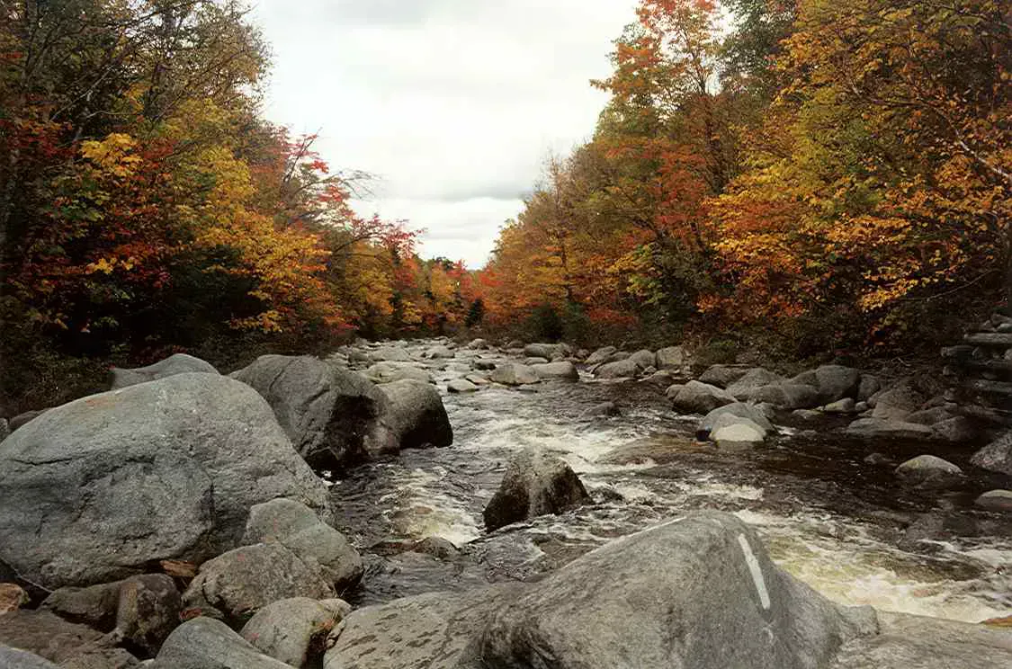
Howe Brook Falls is a series of cascades set in the remote northern section of Baxter State Park, far from the Katahdin crowds that dominate the southern half of the park. The falls drop in multiple tiers along Howe Brook, a cold, clear stream that flows through old-growth spruce-fir forest near South Branch Pond. The total drop across the cascade sequence is roughly 25 to 30 feet, with individual drops of three to eight feet separated by pools and runs.
This is the quiet side of Baxter. While hundreds of hikers queue up at Roaring Brook and Abol for Katahdin on a summer weekend, the northern end of the park sees a fraction of the traffic. South Branch Pond Campground, the basecamp for Howe Brook Falls, is a 30-site tenting area on a beautiful glacial pond surrounded by the Traveler Range. Getting there requires driving the full length of the park’s perimeter road, a commitment that filters out casual visitors.
Howe Brook itself is a model of what a pristine Maine brook looks like. The water is cold and transparent, flowing over a bed of granite cobbles and through pools stained amber by tannins from the surrounding forest. It is tempting to drink straight from a stream this clear, but a packable water filter is the safe way to refill on this remote, services-free hike. Wild brook trout inhabit every pool, and the fishing is managed as catch-and-release with artificial lures only, the same standard that applies throughout Baxter State Park.
South Branch Pond is one of the most beautiful campgrounds in Baxter State Park and a destination in its own right. Reserve a lean-to or tent site and plan at least two nights. Day one, hike to Howe Brook Falls. Day two, climb North Traveler or explore the shoreline of South Branch Pond. The northern park trails see a fraction of the traffic found near Katahdin, and the scenery is equally impressive.
The Hike
The trail to Howe Brook Falls starts at South Branch Pond Campground and follows the Pogy Notch Trail north before branching onto the Howe Brook Trail. The round trip distance is approximately four miles with roughly 350 feet of elevation gain. The trail is well-marked with Baxter State Park blue blazes but is rougher and less maintained than the busy southern park trails.
The first mile follows the north shore of South Branch Pond on relatively flat ground. After leaving the pond, the trail enters dense spruce-fir forest and begins a gradual climb along the brook. The footing turns muddy and rooted here, where boots with good ankle support pay off on the rougher northern-park tread. The sound of the cascades reaches you before you see them, growing louder as you approach.
The falls themselves are spread over several hundred feet of stream, with the trail providing access to multiple vantage points. The uppermost cascade is the tallest single drop, roughly eight feet into a pool carved from granite. Below it, the brook tumbles through a series of slides and small falls, each with its own pool. The trail follows the east bank of the brook, offering views down into the cascading water from above.
The Howe Brook Trail is in remote northern Baxter State Park. Cell service is nonexistent. The trail can be muddy and the brook crossings tricky after rain. Carry a map, water, food, and first aid supplies. Let the ranger at the South Branch Pond gatehouse know your hiking plan before you start.
Swimming and Fishing
The pools along Howe Brook are small but swimmable, with the deepest pool below the main cascade reaching chest-deep in normal water levels. The water is very cold, typically in the upper 40s to low 50s, colder than most waterfalls in the state because of the elevation and the dense forest canopy that keeps the stream shaded.
The brook trout in Howe Brook are wild natives that have never been stocked. They are small, rarely exceeding eight inches, but they are brilliantly colored and feed aggressively on small flies and nymphs. The catch-and-release, artificial-lures-only regulation protects this population. A small fly rod (2-weight or 3-weight) and a few basic patterns are all you need.
The best pool for both swimming and fishing at Howe Brook Falls is the one directly below the main cascade. It is the deepest and has a natural rock shelf on the east bank that serves as a platform for entering the water. The current from the falls keeps the pool clear and circulated. Arrive early because the pool is small enough that two or three people fill it up.
When to Go
Spring
Highest water flow. Cascades are most dramatic in late May and June. Trail is muddy. Black flies. Park roads may not be fully open.
Summer
Driest trail conditions. Warm enough for brief swimming. Brook trout fishing is best. Bugs diminish by mid-July.
Fall
Foliage in the spruce-hardwood forest. Cool, bug-free hiking. Water flow is moderate. Park road closes October 15.
Winter
Park road is closed. Access requires very long snowshoe approach. Not practical for a winter visit.
Summer is the best season for Howe Brook Falls, with dry trails, manageable bugs, and the warmest (relatively speaking) water for swimming. The park road to South Branch Pond typically opens in late May and closes October 15. Reserve campsite early if planning a summer visit.
Packing List
Howe Brook Falls Hike
- Hiking boots (trail is muddy and rooted)
- Water bottle and water filter
- Trail lunch and snacks
- Bug spray and head net (June through mid-July)
- Camera
- Rain jacket and warm layer
- Swimsuit if you want to brave the cold pools
- Fly rod (2-3 weight) and small flies for brook trout
- Map of Baxter State Park trails
- Baxter State Park entrance fee ($15 for non-residents)
Getting There
South Branch Pond Campground is in the northern section of Baxter State Park. From Patten, take Route 159 west to the Matagamon Gate (northern entrance) of Baxter State Park, about 24 miles. From the gate, follow the perimeter road south approximately 8 miles to the South Branch Pond road, then east to the campground.
From Bangor, the drive to Patten is about 1.5 hours via Interstate 95 north to Sherman, then Route 11 north. The total drive from Bangor to South Branch Pond is about 2 hours including the park road.
From Portland, expect 5 hours via Interstate 95 to Sherman and Route 11 north to Patten.
Campsite reservations at South Branch Pond can be made through the Baxter State Park reservation system, which opens in January for the coming season. Sites fill quickly for July and August.
GPS coordinates for South Branch Pond Campground: 46.0780, -68.8890
FAQ
How long is the hike to Howe Brook Falls?
The round trip from South Branch Pond Campground is approximately 4 miles with about 350 feet of elevation gain. Allow 2.5 to 3.5 hours including time at the falls.
Are dogs allowed at Howe Brook Falls?
No. Dogs are not allowed anywhere in Baxter State Park. This is a park-wide rule with no exceptions.
Do I need to camp at South Branch Pond?
No, but it is the most practical option. Day-use access to the northern section of Baxter is possible but requires a long drive on the park perimeter road. Camping at South Branch Pond allows you to start the hike from your campsite.
How cold is the water at Howe Brook Falls?
Very cold. Water temperatures typically range from the upper 40s to low 50s Fahrenheit, even in summer. Brief dips are refreshing; extended swimming is uncomfortable for most people.
Can I combine Howe Brook Falls with a Katahdin hike?
They are in different sections of the park. Katahdin is in the southern section; Howe Brook Falls is in the far north near South Branch Pond. Combining them requires driving the full park perimeter road, about 45 minutes each way. Plan for separate days.