


Fall foliage in Maine is not one event. It is six weeks that roll south from the Canadian border to the coast, with different regions hitting peak in different weeks. If you drive the wrong road in the wrong week, you get green trees or bare sticks. If you time it right, you get the thing you came for: maples in full color, painted against the dark green of spruce and pine.
Here are seven drives that work, with peak timing for each. These are the routes locals actually take, not the ones printed on placemats.
The best color on most of these routes is at the overlooks and short hikes off the road: Coos Canyon, Bald Mountain in Rangeley, Table Rock in Grafton Notch, the Mount Kineo summit. A light daypack for layers, water, and a camera makes those stops easy when an October morning turns cold and wet by afternoon.

When to Go
Maine’s foliage moves south at roughly 25 miles per week. Here is the usual rhythm:
- Northern Maine (Aroostook, Moosehead): Last week of September to first week of October
- Western Mountains (Rangeley, Bethel): First two weeks of October
- Central/North Woods: Early to mid October
- Midcoast and Downeast: Mid October
- Southern Maine: Mid to late October
- Coastal (Portland, Kennebunk): Late October
The Maine Bureau of Parks and Lands publishes a weekly foliage report every Wednesday during the season at mainefoliage.com. Use it. Conditions vary year to year by a week or two depending on summer rainfall and early cold snaps.
| Drive | Length | Peak Week | Region | Difficulty |
|---|---|---|---|---|
| Rangeley Lakes Byway (Rt 17) | 36 mi | Oct 1-10 | Western Mountains | Easy |
| Grafton Notch + Bethel (Rt 26) | 40 mi | Oct 1-10 | Western Mountains | Easy |
| Evans Notch (Rt 113) | 30 mi | Oct 5-15 | Oxford Hills | Moderate (curves) |
| Moosehead Loop (Rt 15/6) | 70 mi | Sep 25 - Oct 5 | North Woods | Easy |
| Schoodic + Downeast (Rt 186) | 27 mi | Oct 10-20 | Downeast | Easy |
| Acadia Park Loop Road | 27 mi | Oct 10-20 | Mount Desert Is. | Easy (one-way loop) |
| Old Canada Road (Rt 201) | 78 mi | Sep 25 - Oct 10 | Western/Kennebec Valley | Easy |
1. Rangeley Lakes Scenic Byway (Route 17)

Length: 36 miles (Mexico to Oquossoc) | Peak: October 1-10
The single best foliage view in Maine is probably Height of Land, and you reach it on Route 17 between Mexico and Oquossoc. The highway climbs over a shoulder of the Appalachians and a pullout at around 2,400 feet opens onto Mooselookmeguntic Lake and the Rangeley Lakes chain, with mountains rolling off to the horizon.
The drive is two lanes, well-paved, with several pullouts. From Mexico, the first 20 miles wind through mixed forest along the Swift River. Stop at Coos Canyon for a quick walk to the gorge. After Height of Land, the road descends into Rangeley, a small lakefront town with a few good restaurants and a bookstore worth an hour.
Keep going northwest from Rangeley to Oquossoc for Rangeley Lake itself. If you have time, loop back via Route 4 through Phillips for a different view of the same country.
Detour: Side trip to Bald Mountain in Rangeley for a 1.6-mile hike to a tower with a 360-degree view of the lakes in color. An hour total.
Height of Land is busy at peak. Arrive before 10 AM or after 3 PM to avoid the crowds. The pullout is small and fills fast. The overlook a quarter mile south (the Mooselookmeguntic Overlook) is less photographed but nearly as good, and usually has space.
2. Grafton Notch + Bethel Loop (Route 26)
Length: 40 miles (Bethel to Upton) | Peak: October 1-10
Route 26 north out of Bethel climbs through Grafton Notch State Park, a narrow pass between the Mahoosuc and Bald Mountain ranges. It is one of the most consistently good foliage drives in Maine because the valley floor, the lower slopes, and the high summits all peak within the same week. The notch concentrates color.
Stops worth making:
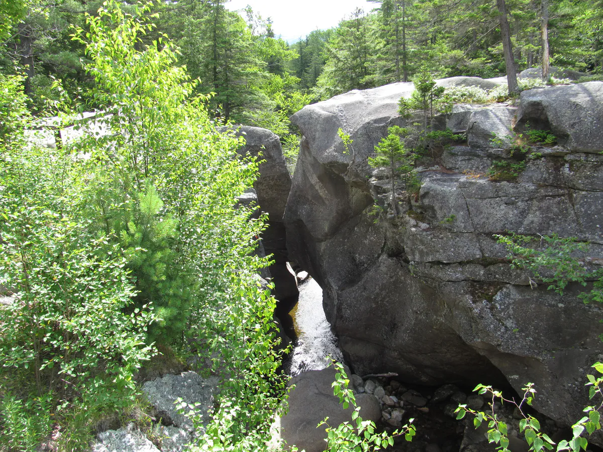
- Screw Auger Falls: A short walk from the highway to a 23-foot cascade through a slot in the granite. Five minutes.
- Mother Walker Falls: Less dramatic than Screw Auger but quieter. Also on the same road.
- Table Rock: 2.4 miles round-trip to an open granite ledge with a view straight across the notch. Steep in places. Plan 90 minutes.
- Old Speck: Maine’s fourth-highest peak. 7.6 miles round-trip, 2,700 feet of climb. All day, but if you want a summit view in October this is the one.
Pair this drive with the White Mountain National Forest in New Hampshire. Route 2 connects Bethel to Gorham in 40 minutes.
3. Kancamagus + Evans Notch (Route 113)
Length: 30 miles in Maine (Gilead to Fryeburg) | Peak: October 5-15
Route 113 is Maine’s quiet answer to the Kancamagus. It cuts south through Evans Notch, crossing in and out of the White Mountain National Forest on the Maine side of the border. The pavement narrows and winds. You drive with the foliage arching overhead instead of off in the distance.
This is a slower drive than most of the others on this list. Plan two hours for the full length, more with stops. The road closes in winter, which is a tell: this is not a major highway. In October it is a beautiful back road.
Along the route you pass into the Caribou-Speckled Wilderness on the west side. A few pullouts lead to short hikes and one overlook at the height of the notch. For camping with foliage views, the Evans Notch campgrounds have sites right on the Cold River.
Route 113 is a narrow, winding road without shoulders in places. It is not suitable for RVs or trailers over 25 feet. Drive it in a sedan or small SUV. Take the curves slowly. Moose are common in the notch.
4. Moosehead Lake Loop (Routes 15 and 6)
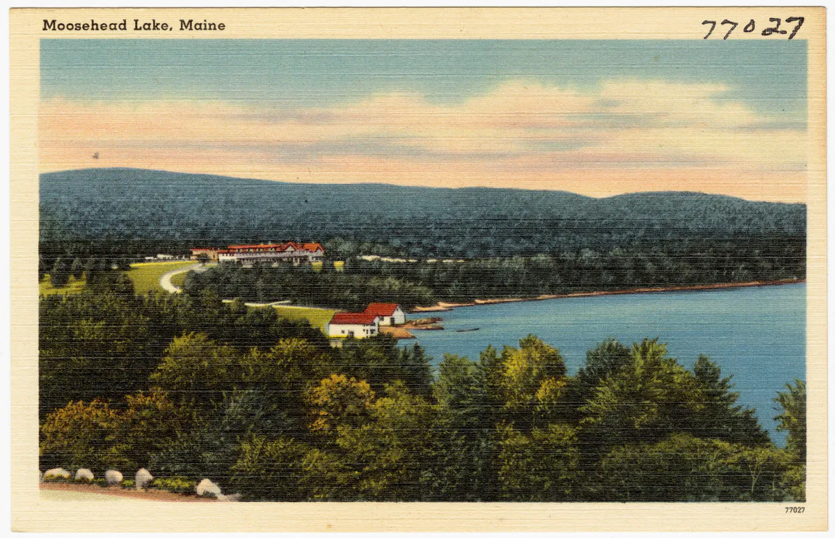
Length: 70 miles (Monson to Moosehead Lake via Greenville and Rockwood) | Peak: September 25 - October 5
This is the drive for early color. Moosehead’s latitude and elevation mean it peaks a week or more before the rest of the state. Route 15 north from Monson climbs into the foothills of the 100-Mile Wilderness, then drops into Greenville at the south end of the lake.
Greenville is the only real town on Moosehead. Stop at the Indian Hill Trading Post for groceries (there is no grocery store for 60 miles in any other direction) and Auntie M’s or the Stress Free Moose for food.
From Greenville, take Route 15/6 west along the lake toward Rockwood. You drive for miles with the lake on your right and the Boundary Mountains rising across the water. Mount Kineo is visible most of the route: a sheer 800-foot cliff rising straight out of the water on its own peninsula.
At Rockwood you can take the seasonal shuttle to Kineo for a hike to the summit. The view from the top, with foliage running up to the treeline in every direction and the second-largest lake in the Northeast spread below, is worth the trip. Check the shuttle schedule before going. Late season runs are weather-dependent.
Detour: Continue past Rockwood to Pittston Farm if you want to see truly remote North Woods foliage. The road is gravel for the last hour and you need to fuel up in Greenville. Not for everyone.
5. Schoodic Peninsula + Downeast (Route 186)
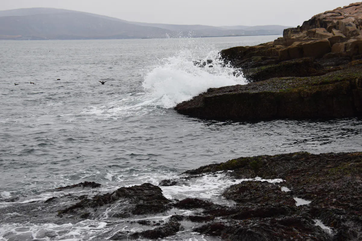
Length: 27-mile loop (Gouldsboro to Winter Harbor) | Peak: October 10-20
Schoodic is the quiet half of Acadia National Park. No reservations. Fewer people. The same pink granite coast. Route 186 peels off Route 1 at Gouldsboro and runs south to Winter Harbor, then loops out around the Schoodic Peninsula on the one-way park road to Schoodic Point.
The drive works in October because the surrounding mixed forest (maple, beech, birch, with dark spruce undertones) peaks right as the crowds in Bar Harbor thin out. You get Acadia-quality scenery without the trail lines.
Schoodic Point itself is the payoff. A broad granite headland with the Atlantic running up against it. The surf can be enormous after a fall storm. Bring a wind shell. The rocks are cold, slippery, and exposed.
After the park loop, Route 186 connects back to Route 1. From there you can continue Downeast toward Lubec and the end of the map, or turn around for Bar Harbor.
6. Acadia Park Loop Road
Length: 27 miles (one-way loop on Mount Desert Island) | Peak: October 10-20
The famous one. And yes, it earns the reputation. The Park Loop Road was designed by John D. Rockefeller Jr. to showcase Acadia, and it does its job. The 27-mile circuit takes in Sand Beach, Thunder Hole, Otter Cliff, Jordan Pond, and the summit road up Cadillac Mountain.
In October you can actually drive it without fighting for parking. The summer shuttle still runs into mid-October. After that you drive yourself, and the experience is different. Quiet. The coastal wind has an edge. The Bubbles reflected in Jordan Pond, with color on all sides, is one of the canonical Maine fall images for a reason.
You need a timed-entry reservation to drive the Cadillac Summit Road. Book ahead at recreation.gov. The rest of the loop is open without reservation.
Start the Park Loop Road at sunrise from the summit of Cadillac. From mid-October to early March, Cadillac is the first place in the United States to see sunrise. In other months it’s a few seconds behind Mars Hill in Aroostook. Either way it’s worth the 4 AM alarm if you like dramatic light.
7. Old Canada Road (Route 201)
Length: 78 miles (Solon to the Canadian border at Jackman) | Peak: September 25 - October 10
Route 201 follows the Kennebec River through the Western Maine mountains up to the Quebec border. It is the longest drive on this list, it has the best big-landscape views, and it is the least crowded. The section from The Forks north is one of the most remote stretches of paved road in New England.
Stops worth making:
- Moxie Falls: 90-foot plunge, one of the tallest waterfalls in New England. Short walk from the highway.
- The Forks: Whitewater rafting hub in summer. Quiet in October. Gas up here; next station is 40 miles.
- Kennebec River Gorge overlook: A couple of pullouts south of The Forks open onto the river running through a narrow gorge with color on both walls.
- Moosehead Lake backcountry: You can detour east from Jackman into the far side of the Moosehead region.
Moose are a real consideration on Route 201, especially at dawn and dusk. Two-ton animals, dark colored, standing on road sides. Drive slow in the last hour before sunset.
Peak Timing by Region (Short Version)
If you have limited time and want to know when to go where:
- Last week of September: Aroostook, Moosehead, Upper Kennebec Valley
- First week of October: Rangeley, Bethel, Grafton Notch
- Second week of October: Western Maine, Oxford Hills, inland Waldo County
- Third week of October: Acadia, Schoodic, Midcoast, Downeast
- Fourth week of October: Southern Maine, coastal York County
Practical Tips
Go midweek if you can. Saturday and Sunday at peak, Route 17 near Height of Land and the Acadia Loop Road are congested. Tuesday and Wednesday are noticeably quieter.
Fuel up often. North of Rangeley, past The Forks, and off Route 1 in Downeast, gas stations can be 30 to 50 miles apart. Fill up when you are under half a tank.
Cell service is patchy. Verizon is the most reliable carrier in the western mountains and the North Woods. AT&T and T-Mobile coverage is thin north of Bangor. Download offline maps before you leave Portland or Bangor.
Weather changes fast. A bright October morning can turn to a 40-degree, wet afternoon in the mountains. Bring layers. Early season snow is possible above 3,000 feet from mid-October on.
Leave the drones at home. Several of the best overlooks (including Height of Land and Cadillac) have restrictions or outright prohibitions on drones. The FAA rules also prohibit drone operation over National Park Service land (including all of Acadia).
When is peak fall foliage in Maine?
Peak moves south through the state over about six weeks. Northern Maine peaks in the last week of September. The Western Mountains peak in the first 10 days of October. Acadia and the Midcoast peak in the third week of October. Southern coastal Maine peaks late October.
What is the best fall foliage drive in Maine?
Route 17 through the Rangeley Lakes is the standout drive for classic western Maine foliage, especially the view from Height of Land. The Acadia Loop Road is the best coastal foliage drive. The Moosehead Lake loop is the best for early color and uncrowded scenery.
How long does fall foliage last in Maine?
About six weeks statewide, from the last week of September through the last week of October. Any single region has a peak window of roughly 7 to 10 days. Miss it by much in either direction and you see either green trees or bare branches.
Is Acadia National Park crowded during fall foliage?
Much less than in summer. Crowds drop sharply after Columbus Day weekend. Mid to late October weekdays are the sweet spot: full color, open businesses, and real parking availability at most trailheads. Schoodic Peninsula is always quieter than Mount Desert Island.
Do I need a 4WD vehicle for Maine fall foliage drives?
No. All seven of the drives in this guide are on paved roads suitable for any vehicle. Some side trips (like gravel roads around Moosehead) benefit from an SUV. Route 113 through Evans Notch is not suitable for RVs or trailers over 25 feet because of narrow curves.
How do I check fall foliage conditions in Maine?
The Maine Bureau of Parks and Lands publishes a weekly foliage map at mainefoliage.com every Wednesday from mid-September through late October. It uses reports from state park staff across the state. It is the most reliable source of real-time conditions.
Image Credits
- Height of Land, Rangeley Lakes Scenic Byway: Photo by Thomas A. Pearl, Federal Highway Administration / National Scenic Byways Program. Public Domain (US federal government work). File page.
- Acadia National Park foliage: Photo by Victoria Stauffenberg, National Park Service. Public Domain (US federal government work). File page.
- Moosehead Lake: Publisher Tichnor Brothers. Public Domain. File page.
- Schoodic Point: Photo by John Manard. Licensed under CC BY-SA 2.0. File page.
- Screw Auger Falls: Photo by Doug Kerr (Dougtone). Licensed under CC BY-SA 2.0. File page.
.jpg)
.jpg)