A Salmon River Through Blueberry Country
The Narraguagus River is one of Maine’s eight remaining Atlantic salmon rivers and one of the least-visited paddling routes in the state. It flows south from the lakes and bogs of interior Washington County through vast blueberry barrens and spruce-fir forest before reaching the tidal waters at Cherryfield, known as the blueberry capital of the world. The roughly 20-mile paddleable section from Deblois to Cherryfield offers Class I-II water, long quiet stretches through undeveloped country, and a profound sense of being somewhere that very few people go.
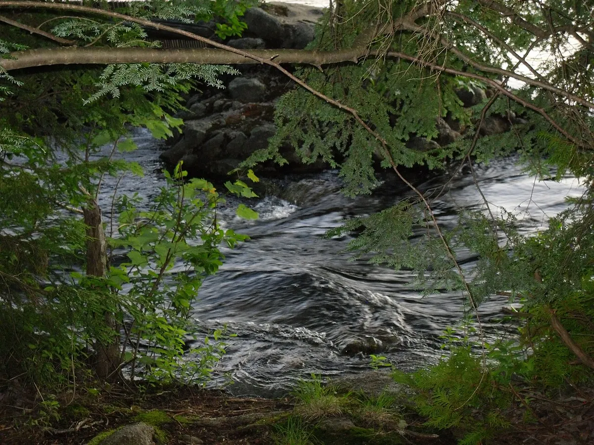
The Narraguagus is a small river. It runs clear over gravel and ledge, dropping through pool-and-riffle sequences that are textbook Atlantic salmon habitat. The restoration efforts on this river are ongoing, and while salmon numbers remain critically low, the river’s health is improving. Paddling the Narraguagus, you understand immediately why salmon evolved to return here: the water is cold, clean, and perfectly structured.
This is Downeast Maine at its most authentic. The landscape is spare and beautiful, the towns are small and working-class, and the river feels like it belongs to another century.
The Narraguagus is a small river that depends on rainfall for navigable levels. In dry summers, the upper sections may be too shallow by late July. Check conditions locally before making the drive. There is no USGS gauge on the upper river, so calling the Cherryfield town office or a local outfitter for current conditions is your best bet.
Paddling the River
The upper put-in near Deblois accesses the most remote section of the river. From here, the Narraguagus winds through thick spruce forest and past the edges of blueberry barrens. The channel is narrow in places, with overhanging branches and occasional log tangles that require ducking or short portages, so solid paddling gear and dry bags pay off. The rapids are Class I with a few Class II drops over ledge shelves.
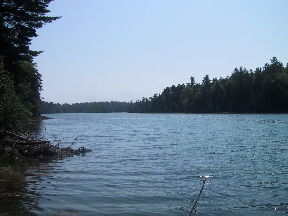
As the river moves south toward Beddington and then Cherryfield, the valley opens slightly and the rapids space out between longer flatwater sections. The gravel bars become larger and more frequent, offering good lunch stops and swimming spots. The water is cold enough to be refreshing even in July.
The final section into Cherryfield is the most accessible and the easiest to paddle. The river passes through Cherryfield’s historic village center, where grand Federal-era houses line the banks, a reminder of the town’s 19th-century lumber wealth. The tidal influence begins below the village, and the take-out at the Route 1 bridge provides straightforward access.
If you want a shorter trip that avoids the tight upper section, put in at the Beddington bridge and paddle the 10 miles to Cherryfield. This stretch has the best balance of easy rapids, open gravel bars, and scenic blueberry barrens. Allow four to five hours for a relaxed pace.
Salmon Heritage
The Narraguagus is one of only eight rivers in Maine where wild Atlantic salmon still attempt to spawn. The species is critically endangered, and the river is the focus of intensive restoration work by federal and state agencies. Counting traps, habitat restoration, and smolt stocking programs are ongoing.
As a paddler, you are unlikely to see a salmon (they are scarce and elusive), but you will paddle through habitat that explains why this species has been worth fighting for. The gravel riffles, cold pools, and clean water of the Narraguagus are exactly what salmon need, and the river corridor has been protected from development specifically to support the recovery effort.
All fishing for Atlantic salmon is prohibited on the Narraguagus. Brook trout fishing is allowed with standard regulations, so bring fishing gear suited to a small, clear stream.
In August, the blueberry barrens along the upper river corridor explode with ripe fruit. If you paddle the upper section in late summer, bring a container and pick wild blueberries on the gravel bars during lunch. The flavor of wild Maine blueberries picked in the sun along a salmon river is a Downeast experience that money cannot buy.
When to Go
Spring
Best water levels for the full river. Cold water, blackflies in June. High water makes upper rapids sporty.
Summer
Warm days, blueberry season in August. Water levels drop. Best for the Beddington-to-Cherryfield section.
Fall
Foliage is at its peak, water may be too low. Salmon are running but fishing is prohibited.
Winter
Frozen or too cold. Not paddleable.
June offers the most reliable water levels for paddling the full river. July and early August work for the lower sections. By mid-August, the upper stretches may be scraping bottom.
Practical Information
There are no outfitters on the Narraguagus. Bring your own boat and arrange your own shuttle. Cherryfield has a general store and a few basic services. For full provisions, stock up in Ellsworth (45 minutes west) or Machias (25 minutes east).
Cell service is spotty in Cherryfield and nonexistent on the upper river. The logging roads to the upper put-in can be confusing; download offline maps before you leave pavement.
Packing List
Narraguagus River Paddle
- Canoe or kayak suitable for Class I-II water
- PFD/life jacket for every paddler
- Dry bag for gear and electronics
- Water shoes for shallow sections
- Sunscreen and bug spray
- Drinking water and snacks
- Fishing rod and Maine license (brook trout only)
- Container for wild blueberry picking (August)
- Shuttle vehicle at take-out
- Offline maps (cell service unreliable)
Getting There
The Cherryfield take-out is at the Route 1 bridge, accessible from Route 1 between Ellsworth and Machias. From Bangor, take Route 1A east to Ellsworth, then Route 1 east to Cherryfield, about 90 minutes.
The upper put-in near Deblois is reached via Route 193 north from Cherryfield. The Beddington access is on Route 193 at the river crossing, about 10 miles north of Cherryfield.
GPS coordinates for Cherryfield take-out: 44.6100, -67.9330
FAQ
Can I fish for salmon on the Narraguagus?
No. All fishing for Atlantic salmon is prohibited on the Narraguagus River. Brook trout fishing is allowed with a valid Maine fishing license and standard regulations.
How difficult is the paddling?
Class I-II rapids that are manageable for intermediate paddlers. The upper section has tight turns and occasional log jams. The lower section from Beddington is easier and more open.
Is the Narraguagus worth the drive?
If you value solitude and authentic Downeast scenery over big rapids or dramatic landscapes, yes. This is a river for paddlers who appreciate quiet water and wild country.
When are the blueberries ripe?
Wild blueberries along the river corridor typically ripen in late July and August. The barrens are most productive in early to mid-August.
Can beginners paddle the Narraguagus?
The lower section from Beddington to Cherryfield is manageable for beginners with basic river skills. The upper section from Deblois requires more experience due to tight turns and log jams.