The View That Stops Traffic
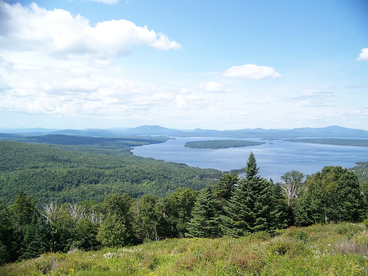
Height of Land is a roadside overlook on Route 17, the Rangeley Lakes National Scenic Byway, perched at roughly 2,200 feet above sea level in Township D, Franklin County. You round a curve heading north from Mexico and the entire Rangeley Lakes region opens up below you without warning. Mooselookmeguntic Lake stretches across the middle distance, its surface shimmering under the sky. Beyond it, ridgeline after ridgeline of spruce-covered mountains rolls toward the horizon. There is no entrance gate, no parking fee, no visitor center. You pull off the road, walk to the stone wall at the edge, and take in one of the most celebrated views in the state of Maine.
The overlook sits at the point where Route 17 crests the height of land between the Androscoggin and Rangeley watersheds. The name is literal: this is the high point, the dividing line where water begins running toward different rivers. The Appalachian Trail crosses Route 17 just south of here, and through-hikers often stop at the overlook before or after the road crossing. For anyone driving the scenic byway, this is the moment the entire drive has been building toward.
What You See
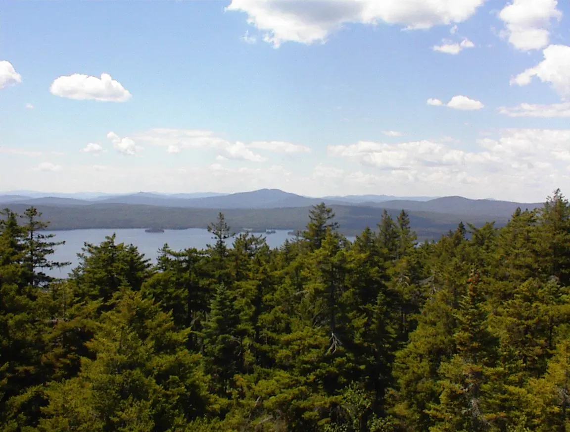
The panorama extends roughly 180 degrees across the Rangeley Lakes region. Directly below and to the northwest, Mooselookmeguntic Lake fills the valley. At roughly 16,300 acres, it is the second largest lake in the Rangeley chain and one of the largest in Maine. The name is Abenaki, variously translated as “moose feeding place” or “portage to the moose feeding place.” The lake sits at about 1,467 feet above sea level, making it one of the highest large lakes in the state.
Beyond Mooselookmeguntic, you can pick out Upper Richardson Lake to the east and the distant peaks of the western mountains. On clear days, the view extends to Saddleback Mountain, Abraham, and the Bigelow Range. The foreground is dense northern hardwood and spruce-fir forest with no development visible, which gives the scene a timeless quality that is increasingly rare on the East Coast.
The Appalachian Trail Connection
The Appalachian Trail crosses Route 17 about half a mile south of the overlook. Northbound thru-hikers reach this crossing after climbing out of the Androscoggin River valley, and the Height of Land view is often their first dramatic panorama of the Rangeley Lakes. For many, it is one of the defining moments of the Maine section. The AT passes through the Bemis Range to the south and continues north toward Saddleback and the Bigelow Range.
Day hikers can access the AT from the Route 17 crossing and walk south along the ridgeline toward Bemis Mountain for increasingly expansive views. The trail is rugged and rocky in this section, but even a short walk along it gives a taste of the backcountry that surrounds the overlook.
When to Go
Summer
Long days and warm weather. The lake and forests are at their greenest. Afternoon thunderstorms can build over the mountains. Morning and evening light are best for photography.
Fall
The premier season. The hardwood forests blaze with color in late September and early October. Clear autumn air provides the sharpest visibility. This is when the overlook is most visited.
Winter
Route 17 is plowed but the overlook pulloff may not be cleared. Snowscape views can be dramatic. Dress for extreme cold and wind at 2,200 feet.
Spring
Mud season in the surrounding woods. The lake is often still partially frozen in April. Views are clear once the spring haze lifts, and the area is very quiet.
Practical Notes
The overlook has a paved pulloff area with room for roughly 15 to 20 cars. There are no restrooms, no water, and no services. A low stone wall runs along the edge of the overlook with no other barriers. The pulloff is on the right (east) side of Route 17 when heading north toward Oquossoc.
The nearest town with services is Oquossoc, about 10 miles north, which has gas, a general store, and a few restaurants. Rangeley village is about 18 miles north and has more options. To the south, the town of Mexico on Route 2 is about 25 miles away.
Getting There
From Portland, take Route 2 west through Farmington to Mexico, then Route 17 north toward Oquossoc. The overlook is about 25 miles north of Mexico on Route 17. The total drive from Portland is about 2.5 hours. From Bangor, take Route 2 west to Farmington, then Route 4 north to Route 17, about 2 hours and 45 minutes.
GPS coordinates for the overlook: 44.8384, -70.7106
FAQ
Is Height of Land free to visit?
Yes. The overlook is a roadside pulloff on Route 17 with no entrance fee, no gate, and no hours of operation. You can stop anytime the road is accessible.
How long should I spend at Height of Land?
Most visitors spend 10 to 30 minutes enjoying the view and taking photographs. If you plan to hike the Appalachian Trail from the nearby crossing, allow additional time.
What lake am I looking at from Height of Land?
The dominant lake in the view is Mooselookmeguntic Lake, the second largest in the Rangeley chain at roughly 16,300 acres. Upper Richardson Lake is visible to the east.
Can I hike the Appalachian Trail from Height of Land?
The AT crosses Route 17 about half a mile south of the overlook. You can day hike south toward Bemis Mountain or north toward Saddleback. The trail is rugged and rocky.
When is the best time for fall foliage at Height of Land?
Peak color typically arrives in the last week of September or the first week of October. The western Maine mountains are among the earliest to turn in the state.