Maine’s Wildest Coastline
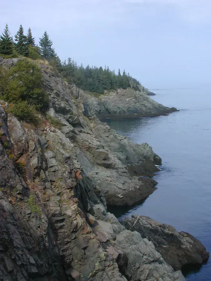
The Bold Coast Trail is what happens when you drive past every tourist town, past every harbor with a lobster shack, past everything familiar, and keep going until the road feels like it might end. In the tiny fishing village of Cutler, on the far Downeast coast of Washington County, a trail drops into spruce forest and emerges on cliffs that drop 100 feet straight into the North Atlantic. This is the most dramatic coastal scenery in Maine, and most people have never heard of it.
The Bold Coast Trail is about 5 hours from Portland and nearly 3 from Bangor. There is no cell service on the trail or in Cutler village. The nearest hospital is Down East Community Hospital in Machias, roughly 30 minutes by car. For a serious injury, rescue response times will be long. Come prepared, tell someone your plans, and carry a first aid kit and a satellite communicator if you have one.
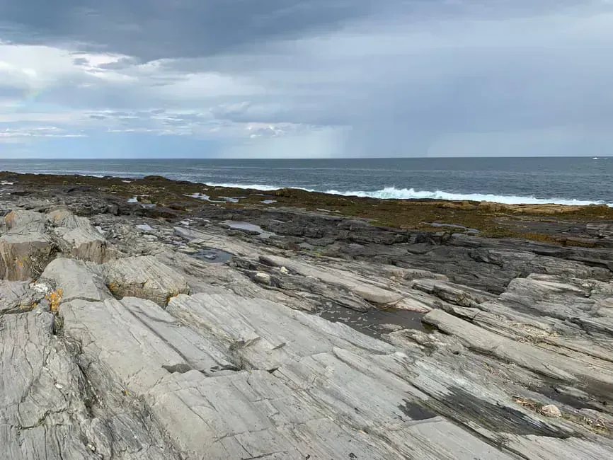
The Cutler Coast Public Reserved Land encompasses 12,234 acres of the boldest coastline in the state. “Bold coast” is a geographic term for areas where land meets sea abruptly, with cliffs and headlands rather than gradual beaches. This stretch defines the term. Dark volcanic cliffs formed 400 million years ago drop vertically into churning surf. Cobblestone pocket beaches sit wedged between rocky headlands. The ocean stretches east toward Nova Scotia with nothing in the way.
Route Options
The trail system offers three main options depending on how much ground you want to cover.
| Route | Distance | Time | Best For |
|---|---|---|---|
| Coastal Out-and-Back | 4.2 miles | 2.5-3.5 hours | First-timers, families, anyone short on time. Hits all the cliff viewpoints and pocket beaches. |
| Black Point Brook Loop | 5.5 miles | 3-4.5 hours | A longer loop that adds forest walking and a stream crossing. Good middle option. |
| Fairy Head Loop | 9.2 miles | 5-7 hours | The full experience. Adds remote headlands, backcountry campsites, and deep forest. Bring lunch. |
Coastal Out-and-Back (4.2 miles)
Most hikers take this route. From the gravel parking lot on Route 191, the path heads south through dense spruce and fir forest. The first mile is flat and quiet, following a well-worn path through thick moss and over exposed roots. You hear the ocean before you see it.
At the trailhead, you will find a wooden sign and a trail registration box. Sign in. In a place this remote, the registration box is how search and rescue knows you are out there.
At roughly the one-mile mark, the trail reaches the coast and the view opens up. The first clifftop overlook is a flat granite ledge with a sheer drop to the waves below. From here, the trail follows the cliff edge south, passing through pockets of wind-stunted spruce and across open headlands. Each point offers a different perspective: some look north along the cliff line, others south toward distant headlands, and several face straight out to sea.
The trail continues to two cobblestone pocket beaches, accessible via short, steep scrambles down from the cliff trail. These small crescents of smooth, rounded stones are wild, gorgeous places to sit and listen to the waves. The stones clatter and shift with each incoming wave, a sound you will not hear on any sand beach. Tides affect access to the pocket beaches. At high tide, some of the beach area is submerged and the scramble down can be wet. Check tide charts for Cutler before your hike.
Black Point Brook Loop (5.5 miles)
This loop extends past the pocket beaches to Black Point Brook, then turns inland and loops back through the forest. The inland section is less scenic than the coast but offers genuine backcountry quiet. Expect bogs with pitcher plants, small stream crossings, and old-growth spruce stands.
Fairy Head Loop (9.2 miles)
For a full day, continue past Black Point Brook to Fairy Head, the southernmost point of the trail system. Fairy Head offers some of the most isolated cliff views on the entire coast. The loop then turns inland, connecting back to the parking area through dense forest. Three primitive campsites along this loop are available first-come, first-served for backpackers (no permit required, no fee).
Camping on the Bold Coast
Three backcountry campsites are spread along the Fairy Head Loop. Each has a fire ring and cleared tent pad, but no water source, no privy, and no other amenities. You pack everything in and everything out.
For something with more infrastructure, Cobscook Bay State Park is about 45 minutes north near Dennysville. It has waterfront campsites, showers, and access to Cobscook Bay’s extreme tides. Reserve through Maine’s state park system.
The fishing village of Lubec is about 40 minutes north and has a handful of motels and B&Bs. From Lubec, you can visit West Quoddy Head (the easternmost point in the United States, with its iconic red-and-white-striped lighthouse) and take the bridge to Campobello Island, New Brunswick, where Franklin Roosevelt’s summer cottage is now an international park.
Wildlife
The remoteness shows in the wildlife. Bald eagles nest along the cliffs and you will likely see at least one soaring overhead or perched in a dead spruce. Harbor seals haul out on rocks below the cliffs, visible from several overlooks. In late summer and early fall, whales sometimes feed offshore, their spouts visible from the headlands.
The spruce forest is home to boreal species like spruce grouse and boreal chickadees that are uncommon further south in Maine. The bogs along the inland trail support pitcher plants, sundew, and other carnivorous plants.
When to Go
Spring
Mud and black flies. Late May is the earliest most people enjoy it.
Summer
Mildest temps (60s), but fog is common. Bring layers and rain gear.
Fall
Clear skies, less fog, empty trails. Spruce stays green, bogs add autumn color.
Winter
Accessible for experienced hikers. Icy access road, brutal cliff winds, no nearby help.
Summer brings the mildest temperatures, though “mild” on the Downeast coast means highs in the 60s with fog rolling in without warning. Bring layers and a rain jacket regardless of the forecast. Fog can appear in minutes and obscure the cliff edges, making careful footing essential.
Fall offers clear skies, reduced fog, and practically empty trails. The spruce forest stays green year-round, but bogs and understory shrubs add autumn color. Late afternoon light on the cliffs in September and October is particularly good for photographs.
Getting There
Fill your gas tank in Machias. The gas station in Cutler village has limited hours and sometimes closes without notice. Machias also has the nearest grocery store, restaurants, and cell service. Stock up before you head south on Route 191.
From Bangor: Take Route 1A to Ellsworth, then Route 1 east through Machias, then Route 191 south toward Cutler. The trailhead parking lot is on the right (west) side of Route 191, about 4.5 miles south of Cutler village. Look for a small brown sign. The lot holds 15 to 20 cars. No restrooms or facilities at the trailhead.
From Portland: Budget 5 hours. Take I-95 to Bangor, then follow the directions above. This is one of the longest drives to any trailhead in this guide. Plan to make a full day of it, or better yet, combine it with a night in Lubec or at Cobscook Bay State Park.
The drive is long but the payoff is real. You will not find anything like this coastline anywhere else in New England. Pair it with a stop at West Quoddy Head in Lubec on your way in or out for a two-destination Downeast trip.
What to Bring
Bold Coast Day Hike Packing List
- 2+ liters of water (no water sources on the trail)
- Rain jacket and layers (even on sunny days)
- Bug spray (summer months especially)
- Trail map or downloaded offline map (no cell service)
- First aid kit
- Lunch and snacks for a full day
- Water shoes for pocket beach exploring
- Binoculars for eagle and whale spotting
Good hiking boots are recommended. The coastal sections have uneven ground and exposed roots, and the scrambles to pocket beaches are steep. Check our tick and bug protection guide and camping gear recommendations if you are planning an overnight trip.
Safety
The cliff edges are unfenced and unguarded. Drops are vertical and fatal. Stay well back from the edge, especially in fog or wet conditions when the rock is slippery. Keep dogs leashed near the cliffs. Children need close supervision.
Cell service is nonexistent throughout the hike and in Cutler village. The nearest reliable cell coverage is in Machias, about 20 miles west. Bring a map, tell someone your plans, and carry a first aid kit. The nearest hospital is Down East Community Hospital in Machias, roughly 30 minutes by car.
FAQ
Can you camp on the Bold Coast Trail?
Yes. Three primitive backcountry campsites are available along the Fairy Head Loop on a first-come, first-served basis. No permits or fees required. Sites have fire rings and tent pads but no water, no privy, and no other facilities. Pack everything in and everything out.
Is the Bold Coast Trail worth the long drive?
If you care about wild, undeveloped coastline, absolutely. There is nothing like it anywhere else in Maine or New England. The 100-foot sea cliffs, cobblestone beaches, and genuine remoteness make it a completely different experience from Acadia or any other coastal hike in the state. Pair it with a stop in Lubec or Campobello Island to make it a full trip.
Are dogs allowed on the Bold Coast Trail?
Dogs are allowed and the trail is manageable for most dogs. Keep them leashed near the cliff edges, which are unfenced with vertical drops. The scrambles to pocket beaches can be tricky for some dogs. Bring water for your dog as there are no reliable water sources on the trail.