


Maine’s Western Mountains are the part of the state most people do not get to. They are harder to reach than Acadia, less famous than Katahdin, and bigger than either. This is where the state’s highest peaks are, where the deepest lakes are, and where the largest share of the waterfalls sit. One region. All of it worth your time.
This is the complete regional guide. Every major trail, waterfall, lake, and town from the New Hampshire border up through Rangeley and east to Carrabassett Valley. Numbers, seasons, and locals’ picks for the good stuff.
What Counts as the Western Mountains
There is no official boundary. Locals and the state treat the region as the chunk of Maine running from the New Hampshire border east past Kingfield, bounded on the south by Route 2 and on the north by the Canadian border. It contains four distinct clusters:
- Rangeley Lakes area. The northernmost cluster. Big lakes, 4,000-foot peaks, the most backcountry feel.
- Carrabassett Valley / Bigelow. Sugarloaf, the Bigelow Range, Flagstaff Lake. The tallest single peaks in the state outside Baxter.
- Bethel / Grafton Notch. The southwestern corner. Slot falls, granite notches, Old Speck, Mahoosucs.
- Oxford Hills / Mount Blue. The foothills and the southern transition into lakes country. Still mountainous, quieter.
If you pick any town from Rangeley to Bethel as a base, you can reach most of the region in a day trip. Neither is more than three hours from Portland.
At a Glance
| What | Signature Pick | Best Season | Effort |
|---|---|---|---|
| Peaks 4,000 ft+ | Sugarloaf, Bigelow, Saddleback | Jun-Oct | Full day |
| Alpine ridge | Bigelow Range traverse | Jul-Sep | Hard |
| Classic day hike | Tumbledown Mountain | Jun-Oct | Moderate |
| Signature waterfall | Moxie Falls / Screw Auger | Apr-Oct | Easy |
| Scenic drive | Height of Land (Rt 17) | Oct peak | Easy |
| Big lake | Mooselookmeguntic, Rangeley | Jun-Sep | Easy |
| Backpacking | Bigelow Preserve, Mahoosuc | Jul-Sep | Hard |
| Family base | Bethel or Rangeley | All | Easy |
Best Hikes in the Western Mountains
The hiking here ranges from 20-minute summits for kids to the most alpine ridge in the state. Grouped by difficulty:
Easy to moderate (under three hours)
- Bald Mountain (Rangeley). 1.6 miles, fire tower at the top, panoramic view of the Rangeley lakes chain.
- Streaked Mountain. Short, steep, big payoff. Views across Pennesseewassee Lake and the Oxford Hills.
- Burnt Meadow Mountain. Fire-rebuilt summit near Brownfield with a ledge view into New Hampshire.
- Mount Cutler. Little-known summit above Hiram. Narrow, rocky, surprisingly mountain-like for its height.
- Singepole Mountain. Easy summit in the southern Oxford Hills. Family-friendly.
- Tire Mountain. Odd name, good ledges, quiet.
- Hedgehog Mountain. Short hike, open ledges.
- Blueberry Mountain. Named for a reason. Mid-August summit for wild blueberries.
- Mount Will. Directly above Bethel. Loop with two viewpoints.
- Step Falls Preserve. Barely a hike, more a walk. A series of cascades within sight of the parking lot.
- Artist’s Covered Bridge. Not a hike, but a great 15-minute detour in Newry.
Moderate day hikes (3-6 hours)
- Tumbledown Mountain. The best day hike in the region. Pond loop, 3,068-foot summit, alpine swimming pond at 2,700 feet. Seven miles.
- Little Jackson Mountain. The longer loop off Tumbledown. Combines nicely for a full day.
- Puzzle Mountain. Grafton Notch classic. Steeper than it looks, with broad summit ledges.
- Table Rock (Grafton Notch). 2.4 miles round-trip up to a cantilevered granite slab overlooking the notch.
- Rumford Whitecap. Open ridge with views in every direction. Blueberries in late summer.
- Bald Mountain (Rangeley) via longer loop. Combine tower and north side.
- Black Mountain (Oxford). Quiet peak with a ledge summit.
- Speckled Mountain (Evans Notch). In the Caribou-Speckled Wilderness. Summit views into New Hampshire and Maine both.
- Caribou Mountain. Speckled’s neighbor. Longer loop through Caribou-Speckled Wilderness.
- Baldface Circle Trail. Technically straddles the NH line. Some of the best exposed ridge hiking in Maine’s southwest corner.
- Bemis Mountain. Part of the AT south of Rangeley. Lightly traveled, excellent views.
- Aziscohos Mountain. Fire tower above Aziscohos Lake. Quiet, remote.
- Tumbledown Dick. Lesser-known cousin of Tumbledown. Worth the detour.
Hard day hikes and overnights (full day or more)
- Old Speck (Grafton Notch). Maine’s fourth-highest at 4,170 feet. 7.6 miles round-trip, 2,700 feet up. All day.
- Sugarloaf Mountain. 4,237 feet, third-highest in Maine. Alpine zone. 6.4 miles round-trip.
- Crocker Mountain. 4,228 feet. Often paired with Sugarloaf on a long AT day.
- Bigelow Range (Avery and West Peaks). Two 4,000-footers and the best ridge in the state south of Katahdin.
- Mount Abraham. 4,050 feet. Harder approach, quieter summit than Sugarloaf.
- Saddleback Mountain. 4,120 feet. Long open ridge, dramatic alpine zone.
For the full 4,000-footer list, see our Maine 4000-footers guide. Seven of Maine’s fourteen 4,000-footers are in this region: Sugarloaf, Crocker, North Crocker, Bigelow West, Avery, Abraham, Saddleback, Saddleback the Horn, and Old Speck (Mahoosucs). Half the list, one region.
Best Waterfalls in the Western Mountains
This region has more waterfalls than the rest of Maine combined. Here is the short list of the good ones:
Must-do (top five)
- Moxie Falls. 90-foot plunge, boardwalk to viewing platform. One of the tallest in New England.
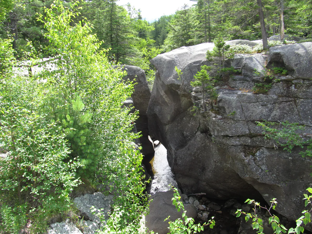
- Screw Auger Falls. In Grafton Notch. Granite slot canyon drop, five-minute walk from the road.
- Smalls Falls. Tiered cascades with deep plunge pools. Swimming hole and picnic area.
- Coos Canyon. Polished granite slot on the Swift River. Swimming, sliding, short gorge walk.
- Angel Falls. 90-foot plunge into a granite amphitheater near Houghton. Quieter than Moxie, about the same height.
Worth the detour
- Dunn Falls. Two-tiered drop in Andover.
- Rumford Falls. A full mill-town river drop. Not wilderness, but impressive volume.
- Mother Walker Falls. In Grafton Notch, a quarter mile from Screw Auger. Less crowded.
- Dingley Falls. Gentle cascade, good summer picnic spot.
- Ellis Falls. Small but photogenic.
- Mosher Hill Falls. Quiet cascade, rarely visited.
- Swift River Falls. On the same river as Coos Canyon.
- Bemis Falls. Rangeley area, deep pool below.
- Snow Falls. Gorge cut in granite, short walk.
- Frenchman’s Hole. A favored local swimming hole with a low cascade.
- Kezar Falls. Small cascade near Lovell.
- Rattlesnake Flume and Pool. Unusual slot-and-pool combination.
- Kees Falls. Off-the-beaten-path plunge.
- Poplar Stream Falls. Carrabassett Valley, short hike.
- Mad River Falls. Lesser-known but pretty.
Peak flow is April through early May as snow melts. July and August they shrink, but the swimming holes open up. Go after any heavy rain in any season.
For a deeper swimming-hole list, see our best swimming holes in Maine guide. Several of the western mountains falls make that list.
Best Lakes in the Western Mountains
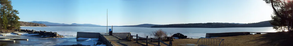
The Rangeley Lakes are the signature. Mooselookmeguntic Lake, Rangeley Lake, Umbagog Lake, Aziscohos Lake, and Kennebago Lake form a chain that dominates the northern half of the region. Big, deep, cold, and full of trout and landlocked salmon. Clean water. Little development.
South of the Rangeley chain, you get a cluster of good lakes and ponds:
- Flagstaff Lake. Below the Bigelow range. Look up from a canoe and you see the whole ridge.
- Webb Lake. Under Tumbledown. Mount Blue State Park sits on its shore.
- Thompson Lake. Oxford Hills area. Good swimming.
- Long Lake. Bridgton area, actually straddles the southern edge of the region.
- Clearwater Lake. Quiet, narrow, clean.
- Wilson Lake. In Wilton. Small, accessible.
- Kezar Lake. Seven miles of surprisingly wild shoreline in Lovell.
- Pennesseewassee Lake. Oxford Hills. Under Streaked Mountain.
- Richardson Lakes. Chain above Rangeley. Backcountry-feeling paddling.
Best swim: any one of them, on a 90-degree day in August, before the afternoon wind picks up. For a broader statewide comparison of swimming lakes, see our best lakes in Maine for swimming guide.
Best Scenic Drives
The driving in this region is part of the experience. Three drives worth your afternoon:
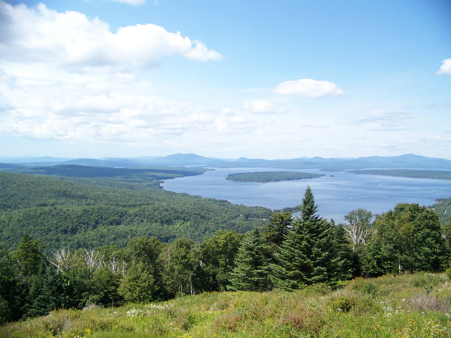
- Route 17 (Rangeley Lakes Scenic Byway). Mexico to Oquossoc, 36 miles. The Height of Land overlook is the single best roadside view in Maine. Peaks October 1-10.
- Route 26 through Grafton Notch. Bethel north to Upton, 40 miles. Passes Screw Auger Falls, Mother Walker Falls, and the Grafton Notch State Park trailheads.
- Route 113 (Evans Notch). Gilead to Fryeburg, 30 miles in Maine. Narrow, winding, quiet. Closes in winter. Passes the Caribou-Speckled Wilderness.
For full details on fall timing, see our Maine fall foliage road trip guide. All three of these drives feature in it.
Towns as Bases
Three towns cover most of the region:
Rangeley
The hub of the northern half. Sits on Rangeley Lake at the end of Route 17. Has a few good restaurants, a bookstore, a grocery store, gas, and outfitters. Good base for: Rangeley Lake, Mooselookmeguntic, Saddleback, Bigelow (via Stratton), the fall drive up Route 17. Low-key, seasonal, quiet in shoulder seasons.
Bethel
The southwestern anchor. Closest town to Sunday River and Grafton Notch. Good restaurants, an inn or two, real groceries. Base for: Grafton Notch, Old Speck, Evans Notch, the Mahoosucs, Caribou-Speckled, Sunday River. Drive 30 minutes to reach most of Grafton Notch trailheads.
Carrabassett Valley
Not really a town so much as a scattered collection around Sugarloaf. Lodging at the mountain, a handful of restaurants in Kingfield. Best base for: Sugarloaf, Crocker, the Bigelows, Mount Abraham. Ski town energy in winter, quiet in summer, trail-running focused.
For a southern-edge base also consider Bridgton or Fryeburg; they get you close to the Oxford Hills cluster and Pleasant Mountain Ledges, though Pleasant Mountain technically sits just east of what most define as the Western Mountains.
4000-Footers in the Region
The western mountains have seven of Maine’s fourteen 4,000-foot peaks:
- Sugarloaf Mountain (4,237 ft). Third-highest. Alpine zone.
- Crocker Mountain (4,228 ft).
- North Crocker (4,228 ft). Same ridge, longer hike.
- Bigelow West Peak and Avery (4,145 and 4,088 ft).
- Mount Abraham (4,050 ft). Harder approach, fewer crowds.
- Saddleback Mountain (4,120 ft). The Horn (4,041) is adjacent.
- Old Speck (Grafton Notch) (4,170 ft). Fourth-highest.
Plus 3,900-footers like Aziscohos, Rumford Whitecap, and Puzzle that nearly make the list.
Seasonal Highlights
Spring (April-May). Waterfall peak. Moxie, Smalls, Coos, Screw Auger all run hardest now. Trails are muddy. Low roads flood. Blackflies start late May. Go for the water, not the mountains.
Summer (June-August). Hiking high country opens up in late June once the snow is off the summits. Swimming lakes warm up; Webb, Rangeley, Kezar, Mooselookmeguntic are all in play by late June. Bugs peak in June, back off by August. Shoulder months (late June, August) are the sweet spot.
Fall (September-October). The reason to come. Foliage peaks in the first week of October in the higher country (Rangeley, Grafton Notch) and spreads through mid-October lower down (Oxford Hills). Height of Land on Route 17 is the best single overlook in the state; arrive early on peak days. Hiking above treeline is cold but clear, with visibility to the White Mountains and the Longfellows both. Book lodging months ahead for the first two weeks of October.
Winter (November-March). Sugarloaf and Saddleback turn into major ski mountains. Cross-country skiing on the Carrabassett trails and Rangeley Lakes Trails Center is world-class. Snowshoeing picks up trails most people only know as summer hikes. Back roads close. Rangeley Lake State Park turns into ice-fishing territory. Dress for real cold: temperatures in the 4,000-footer valleys run 20 degrees colder than Portland.
Where to Stay and Camp
State park campgrounds are the cheapest and easiest bet:
- Mount Blue State Park. Under Tumbledown, on Webb Lake. Best combination of mountain and lake in the park system.
- Rangeley Lake State Park. On the south shore of Rangeley. Swimming, kayaking, easy walks.
- Grafton Notch State Park. No developed campground, but the Grafton Notch area camping options are in the notch itself.
- Evans Notch campgrounds. White Mountain National Forest sites on the Cold River. Primitive but beautifully located.
- Mount Blue State Park camping. The camping side of the park, distinct from the day-use area.
- Rangeley Lake State Park camping. Tent and RV sites on the lake.
Plus the two most remote options: Bigelow Preserve backcountry sites (walk-in) and Richardson Lakes remote ponds for paddle-in camping. Both are best for experienced backpackers.
For inns and houses: Bethel has the most lodging, Rangeley has enough, Carrabassett Valley is ski-season focused. Late September and first two weeks of October book out four months ahead.
Day Trips from Each Base
From Rangeley (one-day picks).
- Height of Land drive + Coos Canyon swim + Smalls Falls walk. Three hours driving, two hours stops.
- Bald Mountain hike (morning) + Rangeley village lunch + Rangeley Lake kayak (afternoon).
- Saddleback or Abraham summit (full day, start early).
From Bethel (one-day picks).
- Grafton Notch grand tour: Screw Auger, Mother Walker, Step Falls, Table Rock. Seven hours with stops.
- Evans Notch drive + Caribou-Speckled hike + Artists Covered Bridge.
- Old Speck (all day).
From Carrabassett Valley (one-day picks).
- Sugarloaf summit (lift-assisted or full hike) + Poplar Stream Falls.
- Bigelow Range ridge (Avery and West). All day.
- Flagstaff Lake paddle + Crocker hike.
What to Pack
- Layers. Summits run 15-20 degrees colder than the trailhead.
- Rain shell always, even on blue-sky days. Thunderstorms build fast.
- Bug head net for June.
- Water shoes for the swimming holes.
- Paper map backup. Cell service is patchy in the notches and across Flagstaff.
- Extra food and water for the 4,000-footers; a day hike here can stretch to eight hours unexpectedly.
- Binoculars for the Height of Land overlook and any ridge hike.
See our what to pack for Acadia post; most of that list applies here, but swap sun gear for more layers.
Fuel up before you head north of Rangeley, before you cross Grafton Notch, or before you push into Evans Notch. Gas stations are 30 to 50 miles apart in the backroads of the western mountains. A cold rainy afternoon with a quarter tank and another hour to pavement is not where you want to be.
Related Guides
- Maine fall foliage road trip
- Maine 4000-footers
- Best easy hikes in Maine
- Best swimming holes in Maine
- Best lakes in Maine for swimming
- Maine outdoor bucket list
- Free things to do outdoors in Maine
- Dog-friendly hikes in Maine
- Where to see moose in Maine
Where are the Western Mountains of Maine?
The Western Mountains run from the New Hampshire border east to Carrabassett Valley, roughly bounded on the south by Route 2 and on the north by the Canadian border. Main towns include Rangeley, Bethel, Kingfield, Oquossoc, and Stratton. The region contains more than 70 hiking trails, 30 waterfalls, 20 lakes, and several state parks.
What is the most famous mountain in Western Maine?
Sugarloaf at 4,237 feet is the best known because of the ski mountain. Old Speck in Grafton Notch is the fourth-highest peak in Maine and the most visited 4,000-footer here. The Bigelow Range is the most iconic alpine ridge. For scenic reputation, the Rangeley Lakes view from Height of Land is probably the most famous image from the region.
Can I visit the Western Mountains as a day trip from Portland?
Yes, but it is a full day. Bethel is about 90 minutes from Portland. Rangeley is closer to three hours. You can easily day-trip Bethel or the Oxford Hills. Rangeley is better as an overnight. Carrabassett Valley is three hours; overnight is essential.
When is the best time to visit the Western Mountains?
First week of October for foliage. July and August for hiking and swimming. January through March for skiing. Late September is the sweet spot overall: cool but not cold, lingering foliage below treeline, crowds manageable, swimming still possible on warm days.
Are there grocery stores and gas stations in the area?
Rangeley has one full grocery (IGA) and two gas stations; Bethel has more of both. Past Rangeley or between Bethel and Stratton, services are sparse. Fill up when you have a chance. Stratton has a small grocery and a couple of restaurants but you should not rely on overnight supplies there.
What are the best hikes for beginners?
Bald Mountain in Rangeley (1.6 miles to a tower), Table Rock in Grafton Notch (2.4 miles to a view), Streaked Mountain (short, steep, rewarding), and Mount Will above Bethel. Tumbledown Mountain via the Brook Trail is moderate but doable for fit beginners, and it is the region's signature hike.
Are there any short, flat walks suitable for small children?
Yes. Screw Auger Falls in Grafton Notch (5 minutes from the parking lot), Step Falls Preserve (also short), Moxie Falls (flat boardwalk, 0.8 miles each way), and Coos Canyon (right off the road with a small gorge walk). All work for toddlers.
What wildlife might I see?
Moose are genuinely common in this region, especially around Rangeley, along Route 16, and in Grafton Notch at dawn and dusk. Black bear are present but rarely seen. White-tailed deer everywhere. Loons on nearly every lake. Beaver, otter, and mink along rivers. Fall hawk migration brings broadwings and sharpshins through the ridges.
Image Credits
- Height of Land, Rangeley Lakes Scenic Byway: Photo by Thomas A. Pearl, Federal Highway Administration / National Scenic Byways Program. Public Domain (US federal government work). File page.
- Mooselookmeguntic Lake panorama: Photo by ThePessimus. Public Domain (released by the author). File page.
- Screw Auger Falls: Photo by Doug Kerr (Dougtone). Licensed under CC BY-SA 2.0. File page. Image shared from the Maine fall foliage road trip post.